INTRODUCTION
Historic cultural artifacts are objects of high importance and value. They give evidence of a civilization’s culture, heritage, and development over time, and often date back thousands of years and are irreplaceable. Thus, the preservation and protection of artifacts against damage or theft is an issue of importance to museums and other conservation organizations.
Developments made in the fields of computer vision and technology have allowed information about artifacts to be archived digitally. These developments have facilitated the use of electronic models and replicas, and have led to numerous organizations, worldwide, increasing research into methods of artifact digitization . (Surendran, Xu, & Stead, 2007)
The three main methods of digitization can be broadly defined as contact digitization, image-based digitization (photogrammetry), and geometry-based digitization (laser scanning). With the development of the latter two digitization methods, and advanced rendering technologies, virtual displays and museums can now be used widely. (Hung, 2007) Furthermore, recent developments in interactive 3-D computer graphics technology have seen an increased interest in, and use of, 3-D digitization for cultural heritage objects. (Muller-Wittig, Zhu, & Voss, 2007) Technologies for reconstructing or remodeling physical components in 3D formats are not new in the engineering field, in particular within manufacturing engineering. However, 3-D digitization used for the preservation and archiving of cultural artifacts is relatively recent.
BACKGROUND
Digitization of artifacts is the process of converting spatial and color information into digital formats. 3-D digitization refers specifically to creating a digital representation of an object in three spatial dimensions, that is, Cartesian x, y, and z coordinates. During 3-D digitization, depth, size, proportion, and textural information about the artifact are recorded and stored in electronic form.
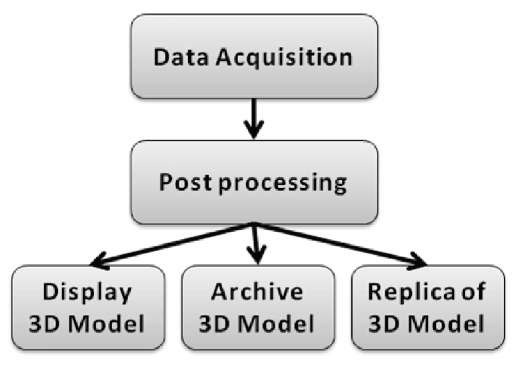
There are a wide range of techniques available in the field of 3-D digitization. The specific approach to digitization differs depending on the artifact and the final intended application of the data. The overall process of 3-D digitization involves three broad steps, as shown in Figure 1. Data are acquired using a method of determining and recording the spatial details of the artifact. The raw data are then processed to form complete rendered 3-D models, and then the data are applied to its intended purpose.
3-D digitization of artifacts is an effective method of archiving historic information. It is currently used within museums and other organizations for documentation and security purposes. Furthermore, electronic models give museums the ability to display digital models on the Internet, increasing public awareness and accessibility to the cultural artifacts. The models also facilitate the use of digital interactive displays within museums, allowing viewers to explore objects without risk of damaging the original artifact. Digital information can also be supplied to computer numerical control (CNC) machines to manufacture accurate replicas or support pieces for artifacts. A further application of digitized data is in analysis of artifacts for historical restoration.
Figure 1. Overall digitization process
CURRENT DIGITIZATION PRACTICES
A number of organizations, worldwide, are promoting research into the digitization of cultural artifacts. These include the Canadian Heritage Information Network (CHIN), the Virtual Heritage Acquisition and Presentation (ViHAP3D) project in Europe, and the Salzburg Research Institute (SRI) in Austria. Some museums are working in collaboration with universities to further research in digitization; in 2004, approximately 35% of museums, worldwide, had initiated developments in some form of 3-D digitization of objects (White, Mourkoussis, Darcy, Petridis, Liarokapis, Lister, et al., 2004). These include the Museum of New York, the Royal Ontario Museum, the Museum of Science Boston, and the American Museum of Natural History. Efforts to establish entire “virtual museums” include The Canadian Museum of Civilization and the National Research Council of Canada collaborating on the production of the Inuit3D Virtual museum, launched in April 2001, and the Computer Science Department of Zhejiang University developing a 3-D Dunhuang cultural relic exhibition system in 2004. (Zhang, Pan, Ren, & Wang, 2007)
The field of 3-D artifact digitization also extends to independent projects, and in several cases, organizations have been assigned specifically to digitize iconic monuments. A project led by Gabriele Guidi, in 2005, involved digitizing the “Plastico di Roma antica,” a model of ancient Rome created in the last century. A modulated light scanner was used to provide the accuracy needed to capture the detail of the model’s features. The scanner was supplemented by a triangulation scanner to capture the more intricate parts of the model (Guidi, Micoli, Russo, Frischer, De Simone, Spinetti, & Carosso, 2005).
In 2004, the spiral motif at England’s Castlerigg stone circle in Cumbria was digitized using the noncontact techniques of laser scanning (using a Minolta 910 scanner) and ground-based remote sensing. No motif was identified through the digitization process, despite the fact that in previous years, the motif image had been observed. This indicated that the spiral was probably painted or had faded due to natural events, and was a novel application of the highly objective methods of 3-D digitization to record the presence of an artifact feature (Diaz-Andreu, Brooke, Rainsbury, & Rosser, 2006).
In 2003, Subodh Kumar, and a team of students from the Johns Hopkins University in Baltimore, undertook the 3-D scanning of ancient cuneiform tablets. Cuneiform documents exhibit writing on three-dimensional surfaces. The team aimed to provide accurate, high-resolution 3-D models of these tablets for scholars’ use in their research and for digital preservation of the unique historical artifacts. A laser triangulation scanner was used, using a regular grid pattern at a resolution of 0.025 mm. It was found that conclusive scanning was a challenge using current technologies (Kumar, Snyder, Duncan, Cohen, & Cooper, 2003).
In 2002, David Luebke, and a team from the University of Virginia’s Computer Science Department, scanned Thomas Jefferson’s Virginia home using a commercial time-of-flight laser scanner, the DeltaSphere 3000. The resultant data from the process was later combined with color data from digital photographs to create the Virtual Monticello, and the Jefferson’s Cabinet exhibits, displayed in the New Orleans Art Museum in 2003 (Wang & Luebke, 2003).
The examples described are just a selection of projects that indicate the diversity of applications of 3-D digitization to cultural heritage artifacts.
DATA ACQUISITION TECHNIQUES
The past 15 years have seen the development of different 3-D data acquisition technologies. These include acoustic position trackers, close range photogrammetry, coordinate measurement machines (CMM), holography, laser scanners, magnetic position trackers, and touch probes. The methods of digitization available can be broadly classified as contact or noncontact (mechanical or optical) techniques. (Surendran et al., 2007)
Contact Digitization
Contact digitizing systems work by manually recording points, on the surface of the object, to be digitized. To acquire each data point a probe is activated and runs over the target object. Contact digitizers are commonly used in reverse engineering and manufacturing applications, and are inexpensive and efficient methods for obtaining digital models of objects with low geometric detail. Though these methods could be extended to artifact digitization, in some cases, the process is slower and does not capture as much geometric information as optical techniques. Furthermore, the process of physically touching the object has the potential to damage the artifact itself. For this reason, the two techniques that are predominantly used for artifact digitization are noncontact techniques of laser scanning and photogrammetry (Granero, Sanchez, Mico, Esteve, Hervas, Simon, & Perez, 2007).
Laser Scanning
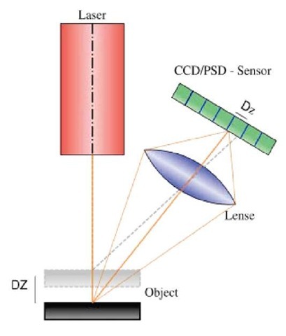
Laser scanning is a method whereby surface information is captured using laser technology. A 3-D laser scanner is an active system that uses laser light to explore the surface of an object with a process called triangulation, as shown in
Figure 2. Lasertriangulation diagram
Figure 2 (Wiora, 2006). During the triangulation process, the scanner projects a laser point to the surface, and an angled camera is used to locate the position of the point in its frame of reference. The information from the location of the laser in the camera’s field of view is used to determine how far away the object is. The process is called triangula-tion because the laser emitter, laser point, and camera form a triangle. The distance between the camera and laser emitter, and the angle of the laser emitter, are known. The angle of the camera corner can thus be determined by looking at the location of the laser point in the camera’s field of view. This information is sufficient to determine the size and shape of the triangle giving the location of the laser point (Beraldin, 2004). In most scanners, a laser beam, rather than a point, is used to aid faster data acquisition.
Photogrammetry
Photogrammetry, also known as optical digitization, is a common technique used for the acquisition of 3-D data from cultural heritage artifacts. It is a remote sensing technique that uses photographic images to form geometrical information about objects. Photogrammetry systems can be roughly divided into passive or active digitization systems (Petrov, Talapov, Robertson, Lebedev, Zhilyaev, & Polonskiy, 1998).
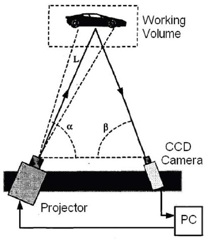
Figure 3. White Lightdigitisation process
Passive systems construct a 3-D model of an object’s surface using stereoscopic images. Most stereoscopic digi-tisers are not truly passive, as they interact with the subject by projecting a grid onto its surface to aid image correlation (Petrov et al., 1998). An example of a stereoscopic system is the stereoSCAN produced by Breuckmann (Figure 3). This system comprises two 1.4mega pixel CCD digital cameras and a central halogen projector for projecting a grid onto the object. The camera angle can be adjusted to cater to different artifacts. Different lenses can also be used to alter the range of measurement (Breuckmann, 2006).
Active photogrammetry systems operate using a trian-gulation technique similar to that used in laser scanning. The difference is that white light, rather than laser light, is projected and reflected into a CCD camera to collect the geometric information (Petrov et al., 1998).
For this reason, they are also known as white light digi-tisers. White light digitisers are able to project light over a larger angle than laser scanners. Because of this, systems are able to project light from the same location as the sensors, and the size of the system can be reduced. This technique is able to capture color data, which makes it even more suitable for cultural artifact applications. A disadvantage is that white light digitisers are generally less accurate than laser digitisers (Petrov, et al., 1998).
POSTPROCESSING OF DATA
The data from scanning systems is in the form of a dense set of surface points, and is often referred to as “point cloud data.” Each point has a distinct position in space dictated by Cartesian coordinates. In the case of color scanners, each vertex will have color information attached to its position data. (Chambard & Chalvidan, 2007)
Postprocessing is the stage responsible for the conversion of this point cloud data into complete and realistic 3-D models. There are several steps that can be implemented to form a final surface model. These include cleaning of irregularities, and the joining of points to form surfaces, filling holes and correcting data, and applying textural or color information.
Postprocessing tasks are generally accomplished by using specifically designed software packages. These software packages not only render scan data into 3-D models, but can also provide an efficient means of reverse engineering. The models created through such software can be further used to generate highly accurate engineering drawings. Two of the most popular postprocessing software packages used in industry are Geomagic Studio and RapidForm.
Point Sampling
Point sampling is the first step to be implemented in postprocessing. In this step, data is selectively removed, which also helps to reduce the size of the data files that are being processed. Noisy data is the data that is captured in the process of scanning, but which is not part of the artifact itself. Noisy data can be removed by sampling large sections of data manually, or by allowing the software package to identify noisy points.
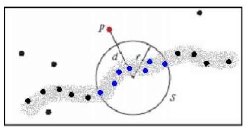
Outliers are erroneous data points that do not fall into the threshold of describing the object surface. This concept is illustrated in Figure 4 (Weyrich, Pauly, Keiser, Heinzle, & Gross, 2004). The thick grey line shows the form of the raw point cloud data, while the threshold P dictates the distance from the bulk of the data at which the point will be recognized as noise.
Figure 4. Outliers in scanned point cloud
Often the distribution of points within a scan is inconsistent. Some areas may have densely populated points while other areas may have sparse point data. Point relaxation is the step that aims to create a point cloud with evenly distributed data. By sampling areas according to a uniform density, redundant data can be removed, and the size of the file can be reduced.
Surface Creation
Once the points have been sampled they are able to be formed into surface data. The surface creation step joins adjacent points, in a process called triangulation, to form triangular faces. Each small face plane is built using three neighboring points. Every data point in the scan data is used to model the surface, and so, depending on the scanner accuracy, surface texture detail can be captured. There is a trade-off between model surface accuracy and data size, as a model generated with a larger number of triangular faces will be more representative of the real object, but requires more data.
Missing data or holes can be filled using software tools within postprocessing packages. Software packages consider surrounding face location to generate a best estimate fit for missing data. This step should be considered carefully in the field of artifact archiving, to preserve the integrity of digital models. Improvement of data accuracy to density ratios (higher accuracy for lower file size) and improved methods of interpolating missing data are likely to continue developing, and present a major research challenge in 3-D digitization.
Color and Texture Mapping
Once a surface model has been created, color data can be applied to the model to create realistic color and texture effects. If the scan data included color information, this data may have remained with the spatial data throughout the cleaning and surface generation stages, in which case, color mapping does not need to take place.
In the case where scan data does not include color information, this can be added through application of photographic images to the surface. Distinct geometric features on the model should be matched with their corresponding location on a photograph to position the image. This step can be difficult to accomplish accurately if surfaces have no distinctive features.
Model Validation
Once a model is produced, there must be a method to determine its accuracy. The simplest method is to compare the original artifact, or images of the original artifact, with the generated model for consistency of features. Dimensions of the final model can be measured on screen and compared to actual dimensions.
A comparison of initial scan data to subsequent surface models can be made within postprocessing software, to form a quantitative test of the deviation of the surface model from its original data. Another method to ensure accuracy is if the textural details of the model surface and color information align. These methods are useful in ensuring that methods used within postprocessing were successful, but do not indicate whether the scan itself contained error. Research is ongoing to improve both the accuracy of scan data itself, as well as model validation methods.
MODEL VISUALIZATION
On completion, models can be displayed in a variety of formats. Exhibiting digitized models online can provide an effective avenue for increasing public awareness and knowledge surrounding historic artifacts.
The original data needs to be exported into a Web-compatible format to enable user viewing. Postprocessing software packages often come with the ability to export model files into publishable formats, for example, RapidForm’s ICF format. Other more generic formats can be used for publication, for example, extensible 3-D (X3D), the ISO standard for real-time computer graphics from Web 3-D Consortium (Web 3-D, 2007) and Adobe Flash. Generic formats can be more easily accessible to users than proprietary display formats.
“Virtual museum” environments can be created to display a collection of artifacts models. Virtual digital museums carry out exhibition, preservation, education, and research through a variety of multimedia avenues, such as Web pages, animation, and video clips. These digital museums play an important role in the fields of information management, sharing, preservation, education, and scientific research (Zhu, Zhou, Sean, Tian, & Yan, 2007).
Security and Cultural Issues
Models that are used for Web site display should be protected against theft and plagiarism. Access to high quality 3-D data online presents the risk that information will be misused, for example, in creating unregistered replicas. Further research needs to be conducted to establish clear formats for protecting electronic information in these formats.
The publication of historic and cultural information online should be handled sensitively. Certain artifacts are culturally sensitive, and the parties concerned may not wish to have 3-D models of the artifacts available online. Consideration of these factors should be made in all digitization and display projects.
FUTURE TRENDS
3-D digitization of cultural artifacts is increasing worldwide. Currently, a large proportion of the projects undertaken use specialized equipment and processes developed for each specific project. As methods become standardized and futher research occurs, optimal digitization strategies may be developed and applied across a wider range of projects.
There are a number of research challenges including improving accuracy of data collection, developing data validation techniques, improving accuracy vs. economic viability of digitization, as well as providing secure Internet data structures for models.
As the standardization of digitization process occurs, methods of 3-D digitization for preservation of cultural artifacts will become more commonplace and accessible to museums. The increased development of “virtual museum” gallery environments will facilitate greater user interaction with artifacts online and across other digital media.
CONCLUSIONS
This chapter discussed the technical aspects of the digitization process, as well as applications in archiving, artifact preservation, and display and replica creation.
The digitization of artifacts offers an attractive alternative solution to preserving the historical information embodied in the spatial and textural qualities of artifacts. An accurate digital form of this information can be stored in multiple locations and safeguarded for future use. 3-D digitization also allows the application of 3-D model data to other purposes outside of digital archiving, for example, the 3-D geometric models give museums the ability to display artifacts on the Internet, increasing public awareness and accessibility to the cultural artifacts. The models may also facilitate the use of interactive digital displays within museums, allowing viewers to explore objects without risk of damaging the original artifact. 3-D geometric models can also be used to produce accurate replicas or support pieces for artifacts. A further application of digitized data is in analysis of artifacts and historical restoration.
It is believed that the field of 3-D digitization will continue to grow in scope as methods of digitization become progressively standardized and accessible. It provides an effective tool in the field of cultural heritage artifact preservation.
KEY TERMS
CHIN: Canadian Heritage Information Network – a network of professionals and volunteers whose objective is to promote the development, the presentation, and preservation of Canada’s digital heritage content for current and future generations.
ICF: INUS compression format file for publication
Point cloud: The collection of points in 3-D space resulting from scanning an object
RapidForm: A comprehensive suite of software designed to convert real-world data from 3-D scanning devices into high quality, accurate, and useful data for a variety of applications.
SRI (Salzburg Research Institute): An institute fully owned by the Province of Salzburg, specializing in digital media
Stereoscopic: Two 2-D images that, when combined, give depth perception.
Triangulation: Within postprocessing of digitized spatial information, the creation of faces or surfaces by joining vertices according to spatial distribution to create triangular planes.
ViHAP3D: Virtual heritage high quality 3-D acquisition and presentation – a project founded by the European Union deigned to increase public awareness of Europe’s most precious artefacts and documents.


