The world of remote sensing changed dramatically on September 24, 1999, with the successful launch of the IKONOS satellite by Space Imaging Corporation. The subsequent launch of the Quickbird satellite by Digital Globe on October 18, 2001 emphasized the dramatically new world that imaging reconnaissance had become.
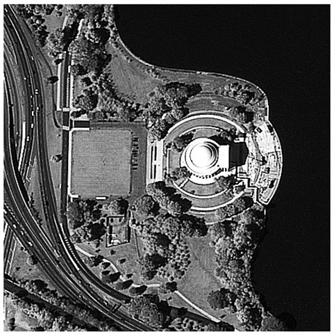
Figure 3.39 First light image from IKONOS of the Jefferson memorial, September 30, 1999.
Images with spatial resolutions of 1 m or better were now available for any customer willing to pay for the imagery.
Satellite and instrument characteristics for the two satellites are enumerated in the table below. IKONOS and Quickbird differ in design; Quickbird is unique for not using a Cassegrain. Both use store-and-dump telemetry systems. Space Imaging uses a large number of ground stations; Digital Globe uses one or two (northern) high-latitude ground stations. Both companies suffered system loss in their initial launches. Digital Globe, launching after Space Imaging, lowered the orbit of their satellite to provide higher spatial resolution and provide an economic advantage over its competitor. A larger focal plane allowed them to maintain a larger swath width.
Table 3.3 Commercial systems.
|
IKONOS |
Quickbird |
||
|
Launch information |
Date: |
September 24, 1999 |
October 18, 2001 |
|
vehicle |
Lockheed Martin Athena II rocket |
Delta II |
|
|
Location |
Vandenberg Air Force Base, California |
Vandenberg Air Force Base, California |
|
|
Orbit |
altitude |
681 km |
450 km |
|
period |
98 min |
93.4 min |
|
|
inclination |
98.1 deg |
98 deg |
|
|
Resolution (GSD) |
pan* |
1-m (nominal at < 26 deg off nadir) |
0.61 m at nadir |
|
MSI** |
4-m |
2.44 m at nadir |
|
|
Swath width |
11 km at nadir |
16.5 km at nadir |
|
|
Revisit frequency |
2.9 days at 1-m resolution; 1.5 days at 1.5-m resolution for targets at 40° latitude |
1 to 3.5 days at 70-cm resolution, depending on latitude |
|
|
Metric accuracy |
12-m horizontal and 10-m vertical accuracy with no control |
14.0 m RMSE |
|
|
Mass/size |
726 kg at launch main body: 1.8 x 1.8 x 1.6 m |
1024 kg (wet, extra hydrazine for low orbit), 3.04 m (10 ft) in length |
|
|
Onboard storage |
64 Gb |
128 Gb |
|
|
Comms |
X-band downlink at 320 Mbps |
payload data X-band downlink at 320 Mbps |
|
|
housekeeping X-band from 4, 16, and 256 kbps |
|||
|
2 kbps S-band uplink |
|||
* panchromatic Imagery
** multispectral Imagery
IKONOS
The IKONOS satellite was launched on September 24, 1999 from Vandenberg Air Force Base. Orbiting at 681 km, it provides 1-m-resolution, panchromatic (visible range) imagery, at a revisit time of 3 days. IKONOS also carries a 4-m-resolution multi-spectral sensor, covering the VNIR portion of the spectrum addressed by Landsat bands 1-4 and the 3 SPOT bands.
One of the biggest advantages of this new generation of satellites is the ability to point significantly off nadir, dramatically reducing revisit time in comparison with earlier systems such as Land-sat. A wider dynamic range makes the sensor more capable as well.29
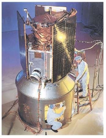
Figure 3.40 Image of the IKONOS satellite in the acoustic test cell at Lockheed Martin Missiles and Space in Sunnyvale, CA.28
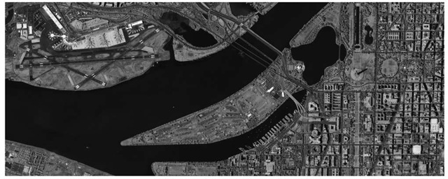
Figure 3.41 First light image from IKONOS, September 30, 1999. The Jefferson memorial is shown at higher resolution above in Fig. 3.39.29
Imaging sensors and electronics for the IKONOS satellite
Camera telescope
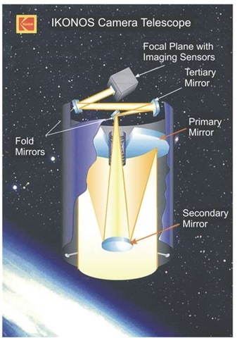
The telescope design is a Cassegrain, with a central hole in the mirror and detectors behind. Three of the five telescope mirrors are curved, and used to focus the image onto the imaging sensors at the focal plane. Two flat mirrors, known as fold mirrors, bounce the imagery across the width of the telescope, thereby reducing overall telescope length from 10 m to about 2 m. The three-mirror anastigmat has a focal length of 10 m, and is anf/14.3 optic. The primary is 0.7 m in diameter x 0.10 m thick, massing 13.4 kg.
Two of the optics can be adjusted for focusing by ground command, should correction be necessary.
Imaging Sensors and Electronics
The camera’s focal-plane unit—attached to the back end of the telescope—contains separate sensor arrays for simultaneous capture of panchromatic (black-and-white) and multispectral (color) imagery. The panchromatic sensor array consists of 13,500 pixels, with a pitch of 12 jam. (Three overlapping 4648 pixel linear arrays.)30 The multispectral array is coated with special filters, and the 3375 pixels have a pitch of 48 j m.
The digital processing unit compresses digital image files from 11 bits per pixel (bpp) data to an average value of 2.6 bpp, at a speed of 115 million pixels/s. The lossless, real-time compression of the imagery is a capability that only recently has been made practical by modern computational resources. It is important that IKONOS and Quickbird offer the extended dynamic range represented by 11 bit data words (Digital number ranges from 0-2047).
Figure 3.42 The IKONOS telescope, built by Kodak, features three curved mirrors. Two additional flat mirrors fold the imagery across the inside of the telescope, thereby significantly reducing telescope length and weight. The telescope is an obscured, three mirror anastigmat with two fold mirrors: a 70-cm diameter primary with 16-cm central hole; 10.00-m focal length, and 1.2-jrad instantaneous field-of-view (pixel).
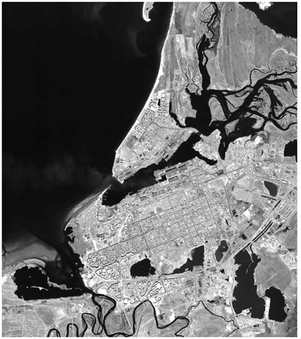
NOB with IKONOS: Severodvinsk
Figures 3.43 and 3.44 illustrate the sort of imagery that can be obtained for regions of strategic interest. First we see a large scene, and then a zoomed view of the sub-marine facility.
Figure 3.43 Severodvinsk, near metropolitan Arkhangelsk, southeast of Murmansk. This is the overview image for the 11740 pixels (Columns) x 12996 pixels (Rows) image. The 0.85-m resolution original was down sampled to 1.0-m resolution before delivery. The original satellite imaging license limited the company to 1-m resolution.
Figure 3.44 Severodvinsk, as captured by IKONOS. Compare the Corona image in Fig. 3.8. Acquisition date/time: 2001-06-13 08:48 GMT, Nominal Collection Azimuth: 133.4306°, Nominal Collection Elevation: 79.30025°, Sun Angle Azimuth: 168.5252°, Sun Angle Elevation: 48.43104°33
