Geoscience Reference
In-Depth Information
Eurasia. The sequence and alignment of landforms, facies
and even individual clasts collectively point to the ice
source regions, ice dynamics and ice limits. They can be
identified using the same zonation as for erosional
landforms (see
Figure 15.13
).
Low erosion rates in Zone
I generate little debris, and glacigenic sediment is sparse
in ice sheet accumulation areas. Many ice source regions
were formerly unrecognized because of their dearth of
conventional glacial landforms. As linear erosion develops
in Zone II, deposition also becomes more significant and
somewhat streamlined in the form of fluted till. High rates
of basal and sidewall erosion in the vicinity of outlet
glaciers in Zone III replicate alpine valley glaciers and
greatly augment in-transit sediment loads.
The landsystem is best developed, however, in Zone IV
(
Figure 15.13
).
Inner, active parts of piedmont glaciers
frequently operate over a range of basal shear stresses at
which thick lodgement till sheets can form and be
deformed, most notably into drumlins parallel to ice flow.
This contrasts sharply with transverse depositional
landforms in outer, progressively more inactive and even
stagnant ice areas at and behind the terminus. The latter
commence with
Rogen moraines
, representing transverse
crevasse and shear plane melt-out in compression zones
behind a static terminus. Transverse
De Geer moraines
are
formed where ice sheds debris beneath a floating tongue
in ponded meltwater (
Figure 15.15
).
The glacier terminus
may be marked by one or more moraines or a
kame
moraine
composed largely of glaciofluvial sediments.
The decisive shift from
ice-contact
to
waterlain
facies
commences with surviving casts of subglacial meltwater
streams, moulin fillings and ice-marginal streams. They
form eskers,
kames
and
kame terraces
respectively, with
internal structures reflecting ice-wall collapse. Ice melt-out
and disintegration are marked by chaotic mixtures of till
and waterlain sediments with few clear landforms, giving
way abruptly beyond the terminus to a
sandur
plain of
wholly glaciofluvial sediments (
Plate 15.15
).
The sequence
of down-glacier facies reflects changes from subglacial to
melt-out/ablation, glaciolacustrine, glaciofluvial and even
aeolian environments. The alignment of clasts, trails of
erratics
derived from rocks upstream and fining-
downstream trends within glacigenic sediments provide
palaeocurrent signatures of ice sheet source and flow
directions.
The dynamics of glacier sedimentation in British and
other piedmont zones are of contemporary interest
because of their links with glaciomarine processes. The
great variability in sediment type and source, clear
evidence of deformation during/after deposition and the
occasional presence of arctic marine shells may point to
lateral ridges or
moraines
. Lateral and medial moraines -
the latter marking the confluence of two ice streams - are
a prominent feature of most alpine glaciers (
Plate 15.14
).
Lateral moraines are linked by terminal cross-valley
moraines where the glacier sheds debris conveyed to its
farthest limit. Deglaciation may be marked by a sequence
of chevron moraines, each recording the receding ice
margin. Retreat moraines from the Little Ice Age advance
are still fresh today and most ice-free alpine cirques
and valleys also contain visible moraines from the last
sedimentary landforms consist largely of amorphous or
hummocky till sheets and fluted moraines interspersed
with waterlain facies. Well defined drumlins and
eskers
(subglacial stream beds) are uncommon. Beyond the
glacier terminus, glaciofluvial sediments form a
valley
train
or braided
outwash plain
confined between the rock
walls. Glaciolacustrine sedimentation in rock basins
and moraine-dammed depressions is a major feature of
deglaciated alpine valleys.
Ice sheet depositional landsystems
Although an ice sheet may advance over 2,000 km from
its ice source, and subsequent retreat, deglaciation and
postglacial environments rework the landscape, the most
extensive glacier depositional landsystem is still associated
with late Pleistocene ice sheets of North America and
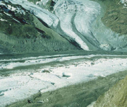
glaciers and its tributary Schmäre and Breithorn glaciers,
Switzerland. The lateral moraines mark Little Ice Age limits of
all three glaciers, and the extent of subsequent retreat.
Photo: Ken Addison