Geoscience Reference
In-Depth Information
(a)
Erosive processes and glacier types
(b)
Erosional landforms
Peripheral mountains
Temperate ice
Alpine glaciers
Mountain glaciation
ice
Outlet glacier
Piedmont
lobe
Abrasion
Abraded
ground
Scour-
'Knock & lochan'
Selective
quarrying
Breaching
-
troughs
Extensive
quarrying
Abrasion
Scour
Z IV
Z III
Z II
Z I
Z II
Z III
Z IV
(c)
Stratigraphy
(d)
Sedimentary landforms
Ice
Till
Glaciofluvial
sediment
Bedrock
Till absent
or thin
veneer
Streamlined till
(drumlins etc)
Glaciofluvial
meltwater
deposits
Moraines
Source: After Addison (1983)
stress and pressure-melting, enabling the ice stream to
exploit weaker bedrock. Quarrying is self-enhancing, as
it draws more ice into the developing rock basin, and this
increases dramatically in the
outlet glacier zone
(Zone III).
In steady state the ELA is located relatively close to ice
sheet margins, nourished and melted in advection-driven
mass and energy balance conditions. This transforms the
ice stream into a temperate, warm-based state and
vigorous outflow draws down adjacent inland areas of the
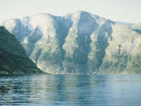
ice sheet through outlet glacier troughs. They are the
most impressive of erosional landforms, excavated 1-5 km
deep and breached clean through any cordillera in their
path regardless of subglacial topography. Transfluent ice
flow on this scale excavated
fjords
through the coastal
mountains of southern Norway (
Plate 15.13
),
the South
Island of New Zealand, British Columbia, Alaska,
southern Chile and - to a lesser extent - western Scotland.
The Finger Lakes region south of Lake Ontario marks
transfluent ice flow towards the southern margin of the
Laurentide Ice Sheet. Beyond the constriction of outlet
glacier troughs, ice fans out in the
piedmont zone
(Zone
IV). Where ice flow is still vigorous it erodes
knock-and-
lochan
topography of parallel
roches moutonnées
inter-
spersed with shallow rock basins which become lake-
filled during deglaciation.
LANDSYSTEMS
Alpine depositional landsystems
Glacier confinement by rock walls also shapes and con-
strains deposition in the alpine environment. Supraglacial
debris derived from the rock walls is usually stacked in
above an arm of Sognefjord, south-west Norway, continuing
for several hundred metres below water level.
Photo: Ken Addison