Geoscience Reference
In-Depth Information
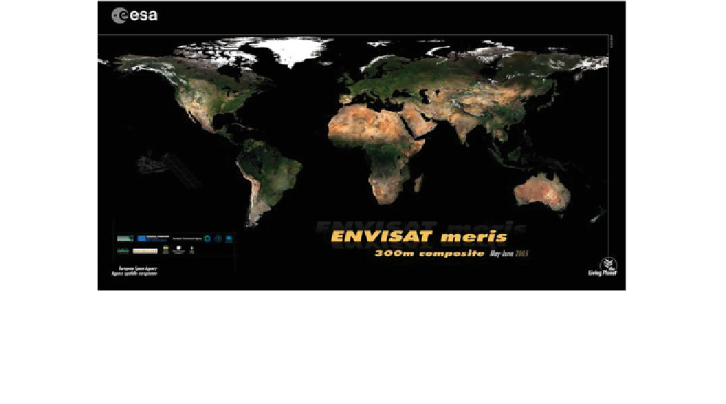
Fig. 11.2
A composite image of the Earth's surface, assembled from
many weeks of observation by the European ENVISAT satellite (to
observe areas at the same time of day, and when they happened to be
clear of cloud). Antarctica was in darkness throughout this northern
summertime observation period and is not shown. Apart from the
Greenland ice cap, the most prominent bright features are the Earth's
deserts at about 30 latitude. In the north, left to right we see the US
and Mexican deserts, then the Saharan and Arabian deserts, Iran and
Pakistan, and the Gobi. In the south, the Atacama, then the Namib and
Kalahari,
then
Australia.
The
same
features
can
be
seen
(but
inverted—dune fields are radar-dark) in Fig.
18.19
The distribution of deserts across the Earth (already
suggested by the satellite mosaic in Fig.
11.2
) is indicated
in a simplified map of the equatorial and mid-latitude
regions of Earth (Fig.
11.3
). The map is annotated with
labels that correspond to entries listed in Table
11.1
, where
some of the named deserts included within a particular
labeled region are indicated. Excluding the vast polar
regions (to which we will return, as they have dunes of their
own), desert regions on Earth are primarily concentrated
around subtropical latitudes, where global wind circulation
patterns are dominated by moisture-deprived air brought to
these locations. The global Hadley cell circulation over the
equatorial tropics, combined with the topographic effects of
large mountain ranges, is the primary explanation for the
distribution of deserts on Earth.
How much sand is included within these global deserts?
This question is more difficult to determine precisely than is
the global distribution of deserts. For example, it is esti-
mated that sand dunes represent about 30 % of the area
covered by all of the Sahara. The Rub' Al-Khali ('Empty
Quarter'), which represents one-quarter of the Arabian
desert, is considered to be largest expanse of unbroken sand
cover present on Earth. Other relevant estimates include
that 90 % of the Kara-Kum desert is sand-covered, whereas
only about 1 % of the Great Basin winter desert in the
western United States consists of sand. Within the sand-
dominated portions of deserts, dunes of many types and
sizes can form, depending upon the local wind conditions
within deserts is strongly influenced by the abundance of
even infrequent precipitation within some deserts, which in
most cases is sufficient to support a wide variety of desert
flora. A few deserts are dominated by unvegetated mountain
ranges with intervening gravel covered basin floors, such as
the Sonoroan desert. Consequently, the availability of
abundant sand-sized material is a crucial factor in deter-
mining where major sand dune accumulations can occur.
Rather than attempting to discuss all of the large deserts
and dune fields on Earth, next we examine some of the
deserts and dune fields that have some unique or specific
attribute that readily distinguishes them from other deserts
and dune fields. This will not be an in-depth treatment, but
rather a brief introduction to some of the more memorable
dry places on Earth. This information will also provide a
broad base from which to explore the dune fields and
deserts on other planetary surfaces.
11.3.1
Sahara
The name 'Sahara' means 'The Great Desert' in Arabic, and
that description is most definitely very appropriate. The
Sahara is the largest non-polar desert on Earth (Table
11.1
),
extending from the Mediterranean Sea on its northern edge
south to the Sahel, a vast tropical savanna that is home to a
diverse range of both flora and fauna that have adapted to
Search WWH ::

Custom Search