Geoscience Reference
In-Depth Information
While some parts of our planet see nearly uniform winds,
the seasonal variations in solar heating, together with the
uneven distribution of thermal inertia (the land warming
and cooling much more than the ocean) mean that some
areas of Earth see predominant wind directions that change
over the course of the year, so much of the planet has a
rather bimodal wind regime. And areas where the high
winds are dominated by moisture-driven storm systems see
highly variable wind directions. This diversity of wind
regimes accounts for the variety of dune-forms on Earth.
The thermal inertia of the surface, and the air density at
the surface, account for the thickness of the atmospheric
boundary layer (which grows over the course of the day to a
thickness of a few hundred meters to a couple of kilome-
ters). This defines the ultimate size of dunes.
Of course, the Earth today is not the Earth that has
always been (see
Chap. 21
). Beyond the more usually-dis-
cussed changes in moisture and wind associated with
astronomically-forced glacial cycles, when one goes back
billions of years in Earth's history, it is worth noting that the
insolation was lower (due to the faint early sun) and the
rotation period was shorter, the receding moon not yet
having robbed Earth of as much angular momentum as it
has today.
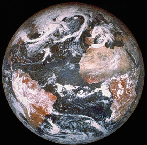
Fig. 11.1
Earth, observed from orbit around the moon by the Clem-
entine spacecraft. The dark Atlantic ocean dominates the scene—as
indeed our planet is 60 % covered by water. Reflective clouds make the
earth a fairly bright object, astronomically-speaking, and are seen in their
near-permanence over the Amazon rain forest at lower left. Towards the
right, the skies over the Sahara are clear, as they often are, exposing the
relatively bright expanse of sand. Over Europe and the north Atlantic,
clouds swirl in cyclonic systems. USGS Mosaic of images acquired on
April 11, 1994, with the moon above about 20
N, 20
W
11.3
Major Deserts and Dune Fields
Deserts are defined as regions that receive less than 25 cm
(10 in.) of rain per year, or where the evaporation rate is at
least twice as great as the rate of precipitation. Most of the
deserts on Earth are not vast regions consisting primarily of
shifting sand, even though movies have tended to make this
the common perception of deserts for many people. Four
types of deserts are recognized by geographers: subtropical
deserts, cool coastal deserts, cool winter deserts, and polar
deserts. The subtropical deserts are the hottest of the four
types, dominated by dry terrain that facilitates rapid evap-
oration. Cool coastal deserts are in the same general latitude
range as the subtropical deserts, but the average temperature
is generally cooler than in the inland subtropical deserts,
influenced by cold off-shore ocean currents near these
deserts. Cold winter deserts experience drastic temperature
extremes and tend to reach much lower temperatures than
those experienced in subtropical deserts. Polar areas are
considered to be deserts because practically all of the water
that makes its way into these regions freezes and becomes
unavailable to support flora. Indeed, the largest deserts on
Earth are the Antarctic and Arctic regions; these polar areas
cover [28 million km
2
, which represents about 60 % of the
cumulative desert area on Earth.
The rotation of the Earth strongly influences the direction
of the solar-driven advective motions that take place in the
atmosphere; over most of the northern hemisphere, the wind
tends to be diverted to the right of its projected path by the
so-called Coriolis force, an 'apparent' force associated with
Earth's rotation (see also
Chap. 3
). The combination of
temperature-driven and Coriolis contributions to atmo-
spheric motion leads to the general features of our wind
patterns. At the surface, this pattern corresponds to the trade
winds, with broad spans of latitude in which the winds are
generally in one or two directions with sufficient reliability
to plan sea voyages (although most of us who travel by air
are perhaps more directly affected today by the stratospheric
winds, the fast-moving jet streams). These trade-wind spans
of latitude are defined by the meridional circulation, with air
rising at the equator and descending around 30 degrees of
latitude north and south, defining what are called the Hadley
cells. As the air has been dried during its ascent, these
descending branches of the cell have little water vapor, and
so these latitudes receive less rain than the planetary aver-
age, and surface evaporation is higher. Thus, deserts form in
two main belts (see Fig.
11.2
), the principal factor con-
trolling where dunes are found on Earth.

Search WWH ::

Custom Search