Geoscience Reference
In-Depth Information
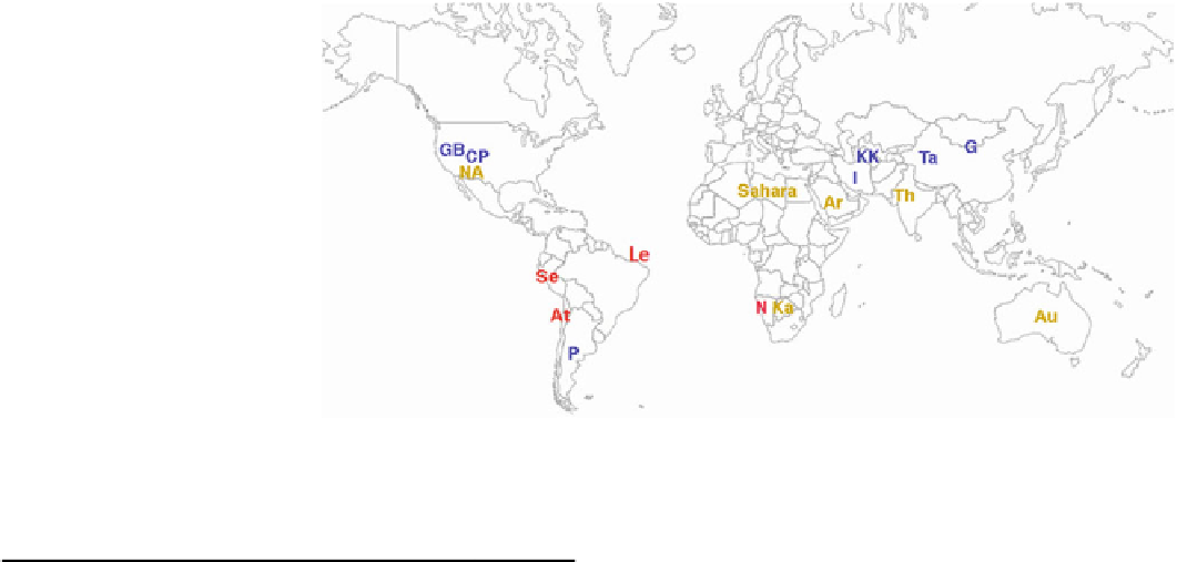
Fig. 11.3
Global distribution of
major desert regions on Earth.
See Table
11.1
for attributes of
the labeled entries. Colors of
labels represent subtropical
(gold), cool coastal (red), and
cool winter (blue) deserts. Polar
deserts are excluded from this
map. 'Le' denotes Lencois
Maranhenses, which is a
dunefield but not a desert
practically no vegetation, causing it to be the source of
massive dust clouds swept off the African continent
(Fig.
11.4
); the sand dunes there can attain heights of up to
180 m. Throughout this vast sand sea, isolated patches of
vegetation collect around the occasional oasis where water
becomes accessible at the surface, usually because the water
table intersects the surface at the lowest areas (Fig.
11.5
). In
contrast to the hyper-arid areas, the northern and southern
parts of the Sahara consist of sparse grassland and shrubs
adapted to semi-arid conditions, where both flora and fauna
become more evident, but they are still not abundant. The
area covered by all of the Sahara is roughly comparable to
the total area of either China or of the United States. The
Sahara (especially Morocco and Egypt) features many
Table 11.1
Major desert regions on Earth
Symbol*
Location (which includes indicated named
deserts)
Area
(10
6
km
2
)
Subtropical deserts
Sahara
Sahara (Libya, Nubian)
9.1
Ar
Arabia (Rub Al-Khali, Ad Dahna, An
Nafud, Syrian)
2.6
Ka
Kalahari
0.57
Au
Australia (Gibson, Great Sandy, Great
Victoria, Simpson)
1.5
NA
North America (Mojave, Sonoran,
Chihuahuan)
0.91
Th
Thar
0.46
Cool coastal deserts
N
Namib
0.034
At
Atacama
0.14
Se
Sechura
0.19
11.3.2
Rub' al Khali
Cold winter deserts
CP
Colorado Plateau
0.49
This name is Arabic for 'Empty Quarter', which indicates
the almost total lack of natural flora and fauna within this
desert in Saudi Arabia (Fig.
11.6
). The Rub' al Khali is the
largest sand desert in the world (Fig.
11.7
), as opposed to
other areas that meet the rainfall definition of a desert but
are not comprised primarily of sand. Like the central por-
tion of the Sahara, the Rub' al Khali is hyper-arid, typically
receiving \30 mm of rain per year. The average daily
maximum temperature is 47 C, but individual locations
have reached as high as 56 C, thus exceeding the typical
high temperature in the Gobi desert. Individual dunes within
the Rub' al Khali are up to 250 m in height. The duneforms
in this vast desert include some of the most 'perfect' linear
GB
Great Basin
0.034
G
Gobi
0.5
KK
Kara-Kum, Kyzyl-Kum
0.56
I
Iran (Dasht-e Kavir, Dasht-e Lut)
0.26
P
Patagonia
0.68
Ta
Taklamakan
0.27
Polar deserts
(Not
shown)
Antarctic and Arctic
28.3
Total
46.6
* Symbols shown on map on Fig.
11.3
the semi-arid climate found south of the desert. About one-
half of the Sahara receives less than 20 mm of rain annu-
ally, while the other half receives up to 100 mm of rain per
year.
The
hyper-arid
central
portion
of
the
desert
has


Search WWH ::

Custom Search