Agriculture Reference
In-Depth Information
creatinG a WaterShed to coLLect
Surface Water
Often, the desire to grade a project so that water is directed toward
other locations on-site—or to create a sheet flow from one area to
another—is not entirely feasible. A reasonable alternative is to simply
sheet flow or direct surface water to be collected either in a detention
pond or a system of catch basins that are connected by underground
piping and carried to a city storm water collection system.
One way to visualize a catchment system is to think of such a sys-
tem as a watershed, a small one perhaps, serving an area of several
hundred square feet or less—or a larger area, but less than one acre.
The photograph in Figure 12.9-A was taken of a portion of a mountain
range in Southern California. The mountains in the photograph make
up three adjacent sub-watersheds, and each of the three is further
subdivided into drainage courses or natural swales. A watershed is an
area bounded by higher landform—for example, a series of ridges with
a swale or V-shaped valley or stream—that carries the rainwater that
falls within the bounded area ultimately to a single watercourse or body
of water, such as a river, lake, wetlands, or ocean. The photograph in
#1
A
#2
#3
Figure 12.9-a
Watershed in Southern California moun-
tains and small watershed-like area within a larger paved
walkway
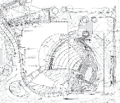
Figure 12.9-B
Portion of a professional grading plan
designed to gather surface water from amphitheater
and behind building to retention pond below
Courtesy of reed hilderbrAnd