Agriculture Reference
In-Depth Information
contours, a topographic survey also includes property lines, existing
features such as vegetation and structures, utilities, utility or other
right-of-way designations, and other above- and belowground features
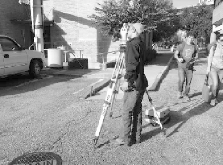
of importance. Figure 7.9 is an example of a topographic survey prepared
by a professional land surveyor for a specific client. The surveyor in Fig-
ure 7-10 is gathering elevation data in an existing parking lot. The infor-
mation will be used to prepare an as-built topographic map, later used
during the re-design of the parking lot, perhaps to correct an existing
drainage problem.
The benchmark in Figure 7.11 is located near the city of Chicago,
Illinois, in Cook County. The bench mark is contained in the Chicago
Loop USGS quad map, 1997. The data sheet containing information on
this bench marker can be found at this URL: http://www.ngs.noaa.gov/
cgi-bin/ds_mark.prl?PidBox=ME1633.
The benchmark image shown in Figure 7.11 is at 598.95 feet above
mean sea level. The elevation and other information related to the marker
can be retrieved at the National Geodetic Survey archives using the E 134
reference on the marker. The marker was given a unique catalogue num-
ber of E 134 that was stamped in the center of the marker with the date on
which the marker was placed in the ground. The following description of
the physical location of the marker was taken from the NGS Datasheet:
Figure 7.10
Surveyor gathering elevations on an existing
parking lot that will be later modified to correct reoccurring
surface rainwater drainage problems
Figure 7.11
USCGS bench mark
sourCe: WikipediA CreAtiVe CoMMons: file usCGs-e134.jpG.
(http://en.WikipediA.orG/Wiki/file:usCGs-e134.jpG)