Agriculture Reference
In-Depth Information
contours 101 and 102, or any point located between any pair of contours,
can be calculated once we know the scale of the drawing.
35.9
34.6
35.3
35.3
36.1
34.5
34.8
35.1
36.8
36.1
34.5
36.0
33.6
34.0
35.7
50"
36.2
33.4
32.9
32.5
h-10
29.9
31.4
31.4
36.1
Te nnis Center
36.1
34.6
34.8
Te nnis Center
35.5
36.2
30.7
30.5
36.5
36.3
35.8
22.5
Playground
Courtyard
Courtyard
35.4
36.3
35.4
35.4
18.5
Fitness
36.4
32.7
34.6
33.1
36.0
GYM
Playground
Fitness Center
18.4
36.1
34.5
awning
awning
33.5
view
35.1
GYM
36.1
Volley Ball Courts
35.7
17.3
33.5
34.2
34.6
34.6
17.6
32.4
35.7
34.7
31.8
35.4
34.7
34.2
35.6
34.6
17.5
33.4
32.4
34.2
35.7
31.6
35.3
16.5
16.8
33.8
35.3
17.2
33.6
34.7
32.8
35.2
34.3
16.5
35.4
34.6
16.1
34.9
33.3
34.5
34.7
15.8
34.8
15.5
34.1
34.6
34.7
34.1
30
34.5
33.9
33.6
32.9
33.6
33.8
34.1
15.4
14.8
33.6
34.1
15.5
14.8
34.2
33.9
33.9
34.6
32.9
15.0
33.9
33.1
14.8
34.0
33.8
14.8
34.0
34.2
34.1
14.6
14.6
33.8
33.9
14.6
14.6
34.6
33.3
33.6
33.8
33.9
33.5
32.4
33.5
32.6
36.7
34.3
33.6
32.7
33.0
33.5
34.8
33.5
14.2
14.1
12.9
34.4
34.7
14.9
32.8
34.1
32.9
32.5
32.4
31.9
32.5
33.0
32.3
33.1
32.8
31.9
33.2
13.4
32.5
31.3
33.3
33.5
34.4
31.7
33.9
32.6
35.2
13.4
34.5
13.2
33.6
12.8
34.5
32.4
31.3
33.1
31.3
34.5
12.2
15.1
34.4
15.2
33.9
15.1
12.3
12.9
32.8
31.3
11.7
14.2
12.7
11.3
11.7
33.1
13.1
10.3
10.7
11.5
17.1
32.2
32.9
10.6
13.2
11.4
10.1
33.2
12.6
12.7
17.7
10.4
11.4
10.4
33.3
17.6
10.4
12.4
9.2
8.4
13.2
9.1
33.3
9.4
10.0
11.3
11.3
10.4
9.4
10.3
9.9
12.1
12.5
11.5
10.5
10.3
10.2
33.3
10.2
11.6
10.1
11.8
9.8
33.7
33.7
33.8
33.7
10.4
11.4
33.9
9.6
10.5
11.3
33.7
9.5
34.1
33.7
33.5
10.4
8.6
10.4
34.9
11.3
34.2
9.5
34.1
34.9
33.7
33.7
8.8
8.7
9.6
34.1
34.7
35.3
34.0
10.2
9.2
33.5
10.3
35.3
36.7
9.4
8.7
35.3
34.4
35.2
35.3
10.5
8.7
34.2
34.5
35.5
9.1
34.3
36.1
35.2
10.4
34.3
34.5
34.2
34.3
33.5
32.7
33.3
50'100'
00'
00'
00'
N
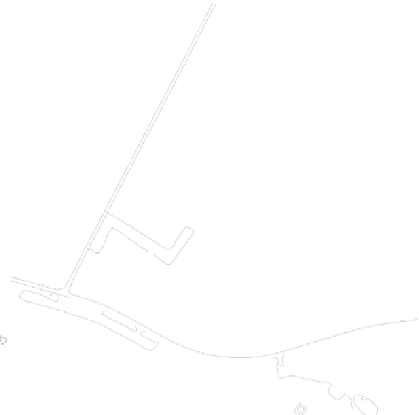
Figure 7.9
Example of a topographic survey prepared by a professional land surveyor
Contours are more than lines on a piece of paper. A contour rep-
resents a continuous line of the same elevation. Each contour on a map
represents an elevation. A contour map is created by a land surveyor
from information collected on a project site using surveying equipment
or a process involving aerial photography. A topographic survey is a map
created by a land surveyor and includes contours and spot elevations
representing the existing terrain or landform. In addition to showing