Agriculture Reference
In-Depth Information
Described by Coast and Geodetic Survey. Located 5.8 miles NW from Chica-
go. About 2.35 miles north along Michigan Avenue from the Illinois Central
Railroad Station at Chicago, thence 0.7 mile north along Lake Shore Drive,
thence 2.7 miles west along W. North Avenue, 116 feet west of the west curb
of N. Milwaukee Avenue, 8 feet north of the north curb of W. North Avenue,
set vertically in the south face and 4.3 feet west of the west edge of the west
door for building number 2018, 4.8 feet east of the southwest corner of the
building, and about 3 feet above the level of the sidewalk.
contourS expLained
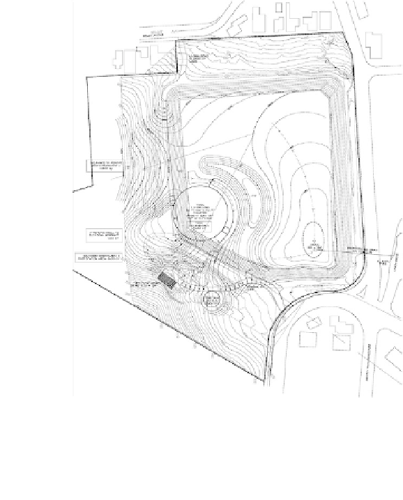
Landscape architects and civil engineers prepare site-grading plans
similar to Figure 7.12 using base information from fieldwork performed
by a professional land surveyor in creating a land or topographic survey
map. Contours with spot elevations are
the graphic means for communicating
to contractors the required landform or
earthwork modifications of an existing
site to accommodate the structures or
activity areas to be built.
The elevations shown on a topo-
graphic map are referenced to the aver-
age elevation of the ocean's surface.
The average sea level elevation is deter-
mined as the halfway point between
mean high and mean low tide. Sea level
elevation is considered the zero contour
line. The dashed line labeled 0 in Fig-
ure 7.13 represents mean high tide, or
zero elevation. The dashed line labeled
1' Contour represents a one-foot eleva-
tion above the sea level. Contour 2 and
Contour 3 represent one-foot elevation
increases. The intent of the photograph
Figure 7.12
A preliminary site-grading plan
Courtesy of dillinGhAM AssoCiAtes