Environmental Engineering Reference
In-Depth Information
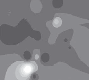
As
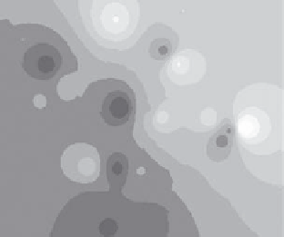
Cr
FIGURE 22.7
Spatial.dispersion.of.As.and.Cr.in.surface.soil.at.the.brownield.site.at.the.location.same.loca-
tion. referred. to. in. Table. 22.2.. Different. shading. categories. are. arbitrary. and. operationally.
deined.using.ArcView.GIS.3.2;.spatial.interpolation.of.inverse.distance.weighted.(IDW).was.
applied.with.12.neighboring.samples.for.estimation.of.each.grid.point..Maximum.As.values.
(darkest.shading).in.the.range.of.75-85.mg/kg,.Maximum.Cr.values.(darkest.shading).in.the.
range.of.60-70.mg/kg.(not.drawn.to.scale).
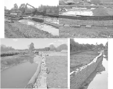
FIGURE 22.8
Contaminated.sediment.from.the.canal.being.dredged.and.deposited.behind.gabions,.before.
sealing.with.geotextile.and.coverage.with.recycled.wastes.
to. comment. on. the. success. and. measurable. outputs. of. this. substantial.
and. costly. remediation. effort. (Figure. 22.8).. It. would,. however,. appear. to.
be.appropriate.to.question.whether.the.remediation.effort.was.justiiable.
and. will. the. aspirational. outcomes. become. a. reality.. Firstly,. in. terms. of.
reducing.risk.and.the.consequences.of.not.taking.remedial.action..As.the.
sediment.continued.to.dry.with.an.increasing.period.of.dereliction,.would.
mobility.of.potentially.toxic.trace.elements.have.become.of.increasing.con-
cern.to.human.health.or.nature.conservation?.Secondly,.is.there.likely.to.
be.a.marked.improvement.of.the.nature.conservation.value.of.the.brown-
ield.land.site.or.the.canal.in.the.longer.term?.It.is.quite.possible.that.this.
Search WWH ::

Custom Search