Geoscience Reference
In-Depth Information
2- The Approach: Using OGC WMS standard for On-Map Word
Cloud Visualisation
The objective of the approach we present in this paper is to verbally visual-
ise the main semantic information that is contained within a map. For this
purpose we use the word cloud technique as an information analysis
method in combination with maps. This method makes use of adding ver-
bal content to the map, as this is one of the most powerful communica-
tional resources available to cartographers.
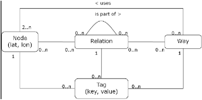
Figure 5:
Section of the OpenStreetMap database schema: Node, Way and Relation repre-
sent geometric entities that can be annotated with zero to n Tag entities specifying their
semantics
For the demonstration of our approach we use the OpenStreetMap (OSM)
dataset.
Figure 5
shows the section of the OSM database schema that models
geometric objects and their semantics. In fact the OSM tags are the seman-
tics of the dataset. OSM tags consist of a key-value pair and specify map
features. They are linked to geometric objects. Each geometric object can
be associated with a multitude of tags that specify its meaning. Tags can
have references to points (table node), lines and polygons (table way) or
complex objects (table relation).
Figure 6
shows a flowchart of the implementation of the application that
overlays an OSM base map with a word cloud processed for the current
map extent. OpenLayers serves as a WMS client and the OSM Mapnik
layer as a base map. The map client requests the server by sending a get-
Map request that conforms to the Open Geospatial Consortium Web Map