Geoscience Reference
In-Depth Information
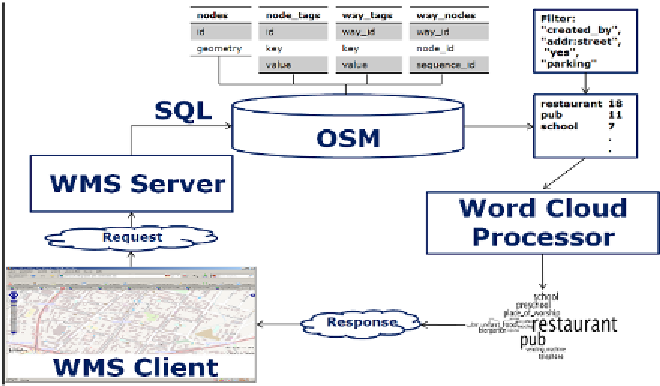
Service specification (Open GIS Consortium 2001). The server queries a
mirrored OSM database, which results in a list of tags and tag frequencies
within the bounding box of the getMap request. In the case of point
objects, tag frequency increases with every occurrence of this tag in con-
junction with a point object. In the case of line and polygon objects a tag
frequency, rises with the number of vertices of line and polygon objects
that are associated with this tag.
Figure 6:
A Flowchart of the process that generates the word cloud layer
OpenLayers, which we used as a WMS client, allows switching between
different layers. In the communication with the WMS server, switching
between different layers is realized by the layer parameter of the getMap
request, which allows the client to specify which keys and/or values will
be presented by the overlaid word cloud. As some keys such as
“created_by” and “address” occur with disproportionately high frequency,
we added the possibility to delete certain tags from the tag frequency list.
The filtered list is then processed by the word cloud layout software. The
produced image is sent back to the client as the getMap response.
The algorithm which is used to layout the word clouds was described by
Viégas et al. (2009). An implementation is available via an executable ver-
sion
3
of the engine that drives the popular word cloud visualisation website
3
Available at: http://www.alphaworks.ibm.com/tech/wordcloud/download.