Geoscience Reference
In-Depth Information
Figure 2
shows results of the application World Explorer, which imple-
ments this approach. A cartographic base map is overlaid with the computed
labels, which results in a map of what we would call popular landmarks.
We have chosen this name because the labels are based on places most
frequently photographed by the users of the Flickr photo platform. The
approach may be used on multiple scales. Results are similar to those of
Milgram's collective mental map with a bias towards tourist attractions.
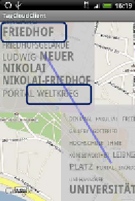
Figure 3
:
Visualisation of geospatial and
non-geospatial context information using
tag cloud visualisations generated from geo-
referenced German Wikipedia articles,
modified after Paelke et al. (2010)
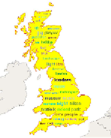
Figure 4
:
The Taggram method - a layout
algorithm that adapts the shape of a tag
cloud to an arbitrary geometric region
(Nguyen and Schumann 2010)
Paelke et al. (2010) use content of geo-referenced Wikipedia articles to
represent context information on maps. They compute tag cloud visualisa-
tions from articles that can be located within a specified map section via
the coordinates given in the article.
Figure 3
shows a result of this work.
The benefit of this approach is its potential to show geospatial as well as
non-geospatial
context information
. It can be seen, for example, that the
terms “Friedhof” (German for “cemetery”) and “Weltkrieg” (German for
“World War”) appear in the same tag cloud and will thus be associated
with each other by the user of the application.
Nguyen and Schumann (2010) present a layout algorithm for tag clouds
that adapts the shape of the cloud to an arbitrary geometric region.
Figure 4
shows a result of this so-called taggram method.