Geoscience Reference
In-Depth Information
in hollows, and a pine forest grows on the
edge of the bog.
• Stage 4 - Narrow bog pools surrounding
irregular hollows and small lakes in the
center (see Color Plate 2-2A). The hollows
may contain pools of standing water that are
perched at levels above the water table and
surface drainage in the surrounding terrain.
The water in the pools inhibits growth of
peat, and the pools gradually expand,
deepen and merge into small lakes that grow
outward through time.
• Stage 5 - Water in central lakes increases
in volume and eventually overl ows and
erodes outlet channels that drain to the sur-
rounding, lower terrain. The original bog is
split by the outlet streams; this process
leads to mire complexes with multiple bogs,
internal lakes, and intervening streams (Fig.
8-6). The pattern of a mature bog may be
quite complicated, depending on its raised
surface, presence of mineral islands, and
distribution of pools, lakes, and streams
(see Fig. 2-25).
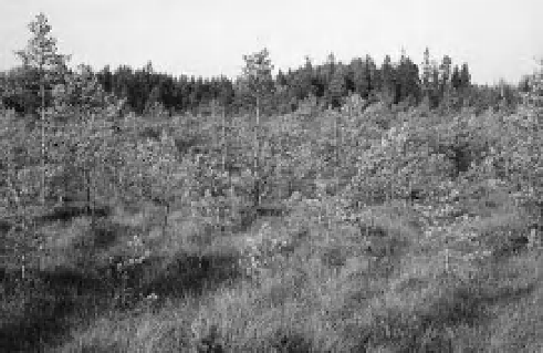
Figure 8-3.
Valgesoo (White mire), a young bog in
southeastern Estonia. Valgesoo is in an early stage of
development (1) and is just starting to become convex
(raised in the center). The central portion, seen here,
shows small pine trees, moss, and grass cover. Ground
water is only 20-50 cm deep (Aaviksoo, Kadarik and
Masing 1997). Photo by J.S. Aber.
This process of hydroseral succession generally
takes several millennia to progress from stage 1
to stage 5. The rate of bog formation may be
determined from thickness and age of the pre-
served peat. In Estonia, for example, the main
phase of bog development began in the mid-
Holocene, 7000 to 4000 years ago, peat accumu-
lated at an average rate of 1.0 to 1.5 mm per
year, and most bogs have peat 5-7 m in thickness
(Masing 1997).
Bogs grow outward as well as upward (Weck-
ström, Seppä and Korhola 2010). Acidic runoff
spills from the raised or blanket bog onto the
adjacent terrain, increases water levels, kills any
trees, and promotes the spread of
Sphagnum
moss. This is one of the main causes of mire
expansion, but people have stopped this process
in many places by digging boundary ditches to
divert bog runoff and protect adjacent forest
and cropland.
Paludii cation and successional changes may
also result from long-term soil development.
Consider a recently deglaciated terrain or a
region uplifted above sea level by tectonic
Figure 8-4.
Teosaare Bog (Snail island mire) displays
sparse cover of dwarf pines and beginning
development of hummocks and hollows with small
pools (stage 2). It is surrounded by pine forest. Kite
aerial photograph by J.S. Aber and S.W. Aber; east-
central Estonia.
growth begins to build hummocks separated
by hollows.
• Stage 3 - Concentric rings consisting of well-
dei ned hummock ridges and linear hollows
following contours on the bog surface. The
mature raised bog begins to show its age
when the surface develops this characteristic
wrinkled pattern of hollows and hummock
ridges (Fig. 8-5). Standing water forms pools