Geoscience Reference
In-Depth Information
reduced or removed. Glacial eustasy, on the
other hand, refers to worldwide changes in sea
level as a consequence of changing volume of
glacier ice on land. Both glacial isostasy and
eustasy, thus, are related to the volume
-
thickness and areal coverage
-
of ice sheets,
but the relationship is neither simple nor fully
understood at present.
8.3.1 Glacial eustasy
At the end of the last major glaciation, the water
held in continental ice sheets in North America
and Eurasia was released into the ocean and
sea level rose by approximately 120 m world-
wide. If the modern ice sheets in Greenland
and Antarctica were to melt, sea level would
rise by another 80 m (Hughes et al. 1981). Thus
the total possible glacioeustatic range of sea
level is on the order of 200 m. During the past
one million years, the Earth has experienced
multiple cycles of glaciation and interglaciation
in which sea level varied by
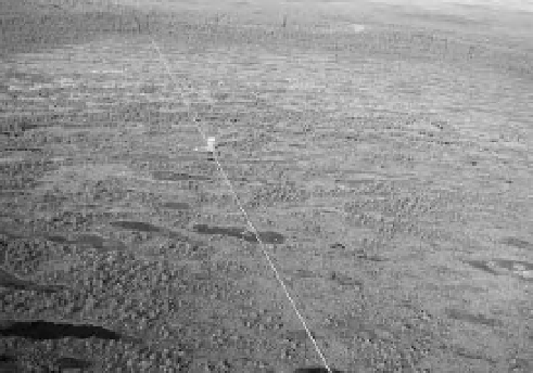
Figure 8-5.
Linear hummock ridges covered by dwarf
pine and intervening pools at the center of
Männikjärve Bog (stage 3). Boardwalk crosses the bog
with observation tower near the center. The
surrounding pine forest can be seen in the background.
Kite aerial photograph by J.S. Aber and S.W. Aber;
east-central Estonia.
movement. In both cases, the suri cial material
consists of sediment or rock that is little
weathered from its original mineral state. As
physical and chemical processes begin to work,
the minerals are broken down into smaller par-
ticles, and soluble compounds are leached out
and transported downward. Microorganisms
and plant roots accelerate these processes, and
organic matter begins to accumulate. In some
situations, a hardpan layer may form within or
below the soil that inhibits downward water
drainage. Retention of surface water and leach-
ing of base cations lead to anaerobic and acidic
conditions that favor the establishment of
Sphagnum
moss and further accumulation of
organic matter. This sequence of events creates
a positive feedback for expanding bogs, which
has happened in many places across North
America from Alaska to Newfoundland
(Charman 2002).
100 m. The records
for these sea-level cycles are preserved in deep-
sea sediments, ice cores from Greenland and
Antarctica, cave formations, and other geologi-
cal sources.
The margins of many continents slope quite
gently into the sea forming wide, shallow con-
tinental shelves. The Atlantic and Gulf coasts of
the United States are good examples. In such
situations, shoreline positions migrated over
tens to hundreds of kilometers as sea level rose
and fell during glacial cycles. These sea-level
cycles could be preserved as intervals of marine
deposits (high sea level) separated by surfaces
of erosion (low sea level). A complete sedimen-
tary record of past sea-level changes ideally
would be developed in stable coastal areas far
removed from glaciation. Much of this sedimen-
tary record is, unfortunately, not directly acces-
sible; it is underwater on the continental shelves.
An excellent record is preserved in South Florida
(Enos and Perkins 1977). Six episodes of high
sea level (interglaciation) are marked by coral
reefs and other marine deposits:
>
8.3 Sea-level change and crustal movements
Glacial isostasy is the process of lithospheric
depression beneath the weight of an ice sheet
and subsequent rebound when the ice mass is
1. Recent (Holocene) sea level, last few thou-
sand years.


