Environmental Engineering Reference
In-Depth Information
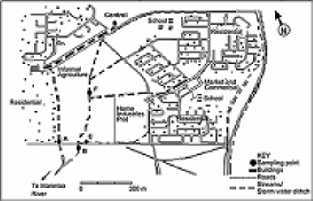
Figure 5.4. Schematic map of the study
area and sampling points.
runoff quality from a mixed pattern area, including residential and commercial patterns,
and part of home industries plot. Point A, on a tributary stream, reflects the contribution
of a purely residential area; and point B represents the combined contribution of all
different types of land use patterns.
The control point was selected at a ground water seepage point, which is the source of
the main stream (points Control, F and B). Sampling was done on five occasions for
points A, B, and F, and on three occasions on point C (when a runoff flow was observed),
and at the control point, during the period November 2001 to February 2002. The
parameters tested were EC, pH, COD, TKN, Ammonia, Nitrate, TP, ortho-P, Fe, Ni, Cd,
Pb, Zn, Cu and FC. The last parameter was determined as numbers per 100 ml of sample
according to the Standard methods (1989). Preservations for TKN (addition of H
2
SO
4
)
and for TP (addition of HgCl
2
) were executed according to the same standard methods.
Nitrate and ammonia were measured immediately after arrival at the laboratory by
selective electrodes (WTW pMX3000/Ion meter); standard curves have been prepared
before the sample collection. For TKN, the Macro-Kjeldhal method was applied. The rest
of the parameters were tested by the same methodology as described in Chapter 4.
3.3
Land use patterns and impacts on water quality
The results regarding stream water quality at points C, F and control are presented in
Table 5.3, results regarding points A and B have been presented and discussed in Mvungi
et.al. (2003). The median values are calculated based on the data sets with a minimum
count of 4. The stream water quality at F presents the impact of informal agriculture,
while point C represents runoff quality from a mixed land use pattern in a low income