Introduction
The use of observation payloads on Earth-circling spacecraft, or satellites, was considered by U.S. military services as early as 1946. The Army Air Force asked Project RAND (Research on America’s National Defense) of Douglas Aircraft Company, Inc, that later became The RAND Corporation, whether the use of space could be of military value. The investigators responded positively in several reports. In an early report in May 1946, RAND suggested that communications could be relayed from a low-altitude Earth-orbiting satellite (1). This was a decade before the launch of Sputnik. RAND issued a final report in 1954 (2), asserting that satellites that had the functions of communications, intelligence collection, navigation, and meteorology could be lofted on rockets being developed for intercontinental ballistic missiles (ICBMs). Curiously, the function of launch detection was omitted.
The use of spacecraft for reconnaissance would be a useful adjunct and, in many instances, a replacement for the use of aircraft that had been employed since World War I. More importantly, spacecraft payloads would provide a less intrusive way to make observations over “denied” territory. To reinforce that concept, President Dwight D. Eisenhower declared an Open Skies Policy in 1955. The policy came about when President Eisenhower proposed to Soviet Chairman Nikita Khrushchev that mutual air surveillance be permitted to control nuclear weapons. The Soviets agreed to the principle, but they opposed the idea of inspection.
Today, military services use spacecraft for communications, navigation, and meteorology for military operations, in a manner similar to their civilian counterparts. In addition, military forces use spacecraft for detecting explosions and launching of rockets and aircraft and for earth observations through imagery and signals intelligence collection. Imagery can provide information on a target before a military strike and bomb damage assessment afterward. Electromagnetic intelligence (ELINT) provides the location and type of radar that indicates whether the radar should be targeted or should be avoided during a mission. The technical details of military spacecraft and their operations are kept secret. This is in contrast to civil and commercial spacecraft and their operations for which information is available to the public on request. The purpose of secrecy is obvious: military movements and information on which they are based should be hidden from enemy, or potential enemy, forces. In addition, the details of these spacecraft and the operations that collect “intelligence” information are also classified.
After World War II, both the Navy and the Air Force began to conduct research and development on space programs. The discussion that follows describes these space programs roughly in the order in which full scale development was authorized. For the sake of continuity, programs of the National Reconnaissance Office (NRO) will be discussed first.
Intelligence Information Collection
National Reconnaissance Office. During the years 1953-1961, President Dwight D. Eisenhower became increasingly concerned about the possibility of surprise nuclear weapon attack by the Soviet Union, a World War II ally turned adversary. Based on advice from trusted scientific advisers, President Eisenhower initiated a number of intelligence collection programs. For example, he authorized the development and production of the U-2 aircraft and its follow-on, the Oxcart (A-12), whose two-seat version became the better known SR-71. These aircraft were designed to collect imagery over the Soviet Union to evaluate its military capability and, indirectly, the intent of its leaders.
During these years, the U.S. Air Force began to develop spacecraft for imagery collection (SAMOS) and infrared rocket plume detection (MIDAS) (2), under a Weapon Systems program, WS-117L. In late August 1960, to limit access by the press, tighten security, and reduce possible objections from the Soviet Union about the United States development of a weapons system for space, President Eisenhower transferred the imagery program from the Air Force to a newly established covert organization that ultimately became the National Reconnaissance Office (NRO). His action changed the national priority. Intelligence data collection would first be devoted to strategic indications and warning of an attack on the United States and second to tactical military operations. The new Secretary of Defense of the Kennedy administration, Robert S. McNamara, formally established the NRO, now composed of elements of the Air Force, Central Intelligence Agency, and the Navy, on 6 September 1961. As its first Director, he named Dr. Joseph V. Charyk, then the Under Secretary of the Air Force (2).
Ten years later, the NRO had evolved into a progressive organization responsible for research, development, acquisition, launch and operation of space systems for reconnaissance. The original concept was that a few very talented individuals would staff the organization, lay audacious plans, and guide it. They would depend on contractors to perform the research and development, produce the payloads, satellites, boosters, and in-orbit control vehicles. Launch and in-orbit control were to be conducted by teams of government and contractor personnel. Government teams were comprised of civilian and military personnel. This arrangement permitted rapid communication to take advantage of new technology, on the one hand, and on the other, to learn about operational difficulties that needed correction in later spacecraft and in in-orbit control techniques.
Organizationally, the NRO had a Director, a Deputy Director, and a small headquarters staff whose elements reported to a Director of the Staff. The field offices were organized as follows: Program A—U.S. Air Force, Secretary of the Air Force Special Projects (SAFSP), for some spacecraft programs and all launch vehicles; Program B—or CIA Reconnaissance Programs using both spacecraft and aircraft activities; Program C—U.S. Navy for spacecraft; and Program D—U.S. Air Force aircraft activities. These offices competed with each other in acquiring new technology and systems, sometimes constructively and sometimes not. The various projects within the NRO field offices were structured for maximum efficiency (stovepiping), not necessarily with commonality of architecture, subsystems, or components. The Gulf War in 1991, Operation Desert Storm, proved both the value of the NRO products and the difficulty of delivering them to the military field commanders. This is not surprising because the NRO was never intended to support military operations in the field.
The NRO delivered the collected photographs to the National Photographic Interpretation Center (now a part of the National Imagery and Mapping Agency) to extract intelligence from the imagery. The NRO delivered radar and communications intelligence data to the National Security Agency for signals intelligence, in general, but the CIA processed telemetry intelligence until about 15 years ago. The analyzed intelligence products were delivered to analytical intelligence organizations responsible for national estimates and to strategic and tactical military forces. Collection requirements for the NRO reconnaissance assets were developed by these users of the information.
Corona Operations: Imagery Collection. The first covert reconnaissance spacecraft was approved for full-scale development by President Eisenhower in 1958 and was called the Corona program (3-7). “Discoverer” was the overt name of Corona, but Discoverer had some missions of its own. After 13 previous tries, Corona Mission 9009 was successfully launched from Vandenberg Air Force Base on 18 August 1960, on a Thor Agena booster and second stage. This fourteenth attempted launch occurred on the very day that Gary Powers was being sentenced in Moscow for the U-2 shootdown. This Corona mission collected imagery of one-half the area compared to that collected by all U-2 flights to date. This mission photographed 1.5 million square miles of the Soviet Union and East European countries. It photographed 64 Soviet airfields and 24 new surface-to-air missile (SAM) air defense sites. Ferret aircraft flying along the periphery of the Soviet Union and the Warsaw Pact countries had collected earlier detections and locations of SAM sites. This first successful mission of Corona impressed all those who viewed the photographs, from the analysts to President Eisenhower.
It should be noted in passing that the thirteenth attempted launch of Corona was also successful, but it carried diagnostic instrumentation rather than a camera and film load. The rocket boosters of that era did not have enough lift capability to carry both a photographic payload and sufficient instrumentation to measure the performance of the rocket during the launch phase and the spacecraft in-orbit.
The resolution of the panoramic KH-1 camera was 40 feet at nadir. The camera photographed from one side horizon to the other and slightly overlapped adjacent photographs in the direction of its travel trajectory. “Resolution” is the ability to separate and discern the narrowest two lines of equivalent width and spacing, assuming good contrast between, say, white lines and black background as in a parking lot. Resolution should not be confused with detecting the narrowest width white stripe on a black background in a parking lot. The resolution achievable from a spacecraft payload depends on the telescope of the camera, specifically, the lens aperture and the focal length. More importantly, it depends on the altitude of the spacecraft, on the (image) motion compensation (note, however, that it is the camera that is moving) and on the stability of the camera and the absence of vibration. For a film based camera, a simple calculation of the diffraction limit will yield a resolution that is better by a factor of about 10. The Corona camera went through a number of modifications which were numbered KH-2, -3, -4, -4A, and -4B, and the resolution ultimately improved to 5 feet. Stereoscopic capability was added so that analysts could view the targets in three dimensions. The U.S. Army Topographic Command, which later formed the core of the Defense Mapping Agency, could now produce terrain maps from Corona imagery.
Because a typical mission was only a few days long, there was a concerted attempt to increase the number of operating ”days in orbit.” The amount of film carried was increased and was eventually spooled into two capsules that were recovered separately. The amount of orbit adjust gas stored on board was increased to permit longer missions. Because a single satellite could not photograph any location on Earth immediately on demand, the NRO produced a term called ”near real time.” That meant that photographic coverage could be obtained only when the satellite made a pass over the target whose photograph is desired. Today, this term is also used to mean the time taken to process data that have been collected, but that was not the original meaning. To improve the daily coverage, more missions were orbited or ”flown,” and the result was that in the late 1960s, and early 1970s, the NRO dominated the number of U.S. space launches per year.
To recover on earth an exposed film capsule attached to the Corona satellite required a carefully orchestrated sequence of events. It began with separation of the capsule from the spacecraft, followed by firing retrorockets to decelerate the capsule, appropriate stabilization for reentry, the deployment of parachutes to slow the fall through the sensible atmosphere, and snatching the assembly in mid-air by a crew flying a C-130 cargo aircraft based in Hawaii and equipped with a special harness.
A casual belief that once launched, a satellite will stay in that particular orbit, is actually incorrect. The satellite orbit is perturbed by the very unsym-metrical gravitational field of Earth. In geosynchronous Earth orbit, for example, there are only two stable points toward which all satellites tend to move. In addition, atmospheric drag changes the orbit of low-altitude satellites considerably in unpredictable ways. It is known that an atmospheric bulge is produced on Earth about 7 hours after a solar flare occurs. On one occasion, Corona passed over a ground control station one minute late, indicating an ephemeris uncertainty of 240 nautical miles!
In later years, Corona was flown at an altitude of about 100 miles at a somewhat retrograde inclination of about 110°. The last Corona mission occurred in 1972, and it was replaced by spacecraft that had greater capability. Because all space-qualified spacecraft had been launched, a working model was assembled, and given to the Smithsonian Institution (Fig. 1).
Operations for Corona were directed from an NRO Operations Center in a secure vault in the basement of the Pentagon. The Operations Center had detailed data on the dates that cloud-free photographs had been collected over targets and areas of interest. The users of the intelligence information specified the targets and frequency of collection as collection requirements. From these data, personnel at the Operations Center sent general collection directions by classified message to the Satellite Control Facility at what is now Onizuka AFB, named after the astronaut who was aboard the Shuttle Challenger when it exploded soon after launch. Onizuka AFB is located in Sunnyvale, California. From there, detailed instructions were sent to ground stations around the world. The ground station personnel loaded the instructions by microwave data links onto Corona for execution. The ground stations had cloud cover data from the weather satellite described later to influence the instructions to the film-limited Corona satellite.
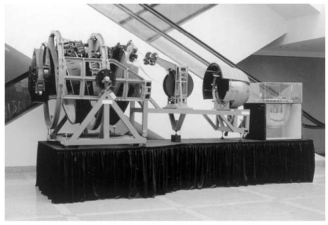
Figure 1. Corona photographic satellite viewed from the side. Note on the left the two panoramic cameras for stereoscopic photographs and the film capsule on the right.
Corona Products: Importance of Imagery—the Cold War, Arms Control, Weapons of Mass Destruction, and Verification. In the early days of the Cold War, it was important for the U.S. government to understand the military capability of the Soviet Union, as mentioned earlier. The ability to verify compliance with the Treaty became important as various treaties, such as the Strategic Arms Limitation Treaty I, were signed with the Soviet Union. That was to ensure the United States of compliance by the Soviet Union and also to confront them on practices that restricted verification, such as sheds to protect workers from weather conditions over missile silos and submarine pens. On a number of occasions, the Soviet Union confronted the United States about its practices to which they had objected, so the activities were symmetrical. The methods and technologies of collecting verification data came to be known as National Technical Means (NTM) in the arms control community.
Corona played a vital, but by no means the sole NRO, NTM role in monitoring the 1972 SALT I Interim Agreement on Strategic Missiles. By then, the NRO had other photoreconnaissance satellites in operation. Nevertheless, Corona’s wide area search capability provided early detection of possible ICBM launch complexes under construction. Corona located the first Soviet ICBM complex at Yurya (Fig. 2), 500 miles east of Moscow (8). It was observed that one of the launch sites at this complex was dismantled as a result of the Interim Agreement.
In countries other than the Soviet Union, Corona (KH-3) Mission 9029 provided the first coverage of a Chinese nuclear test site near Lop Nor in December 1961 (8). In August 1964, the Director of Central Intelligence published a Special National Intelligence Estimate that assessed the likelihood that
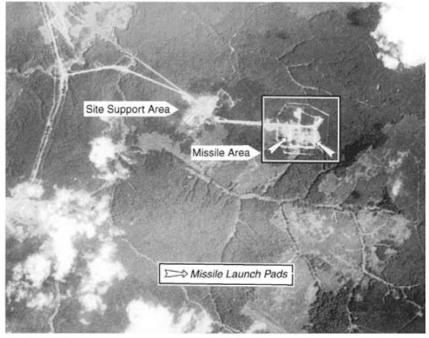
Figure 2. Corona photograph of ICBM complex at Yurya, USSR.
China would detonate its first nuclear device in 1964. Four days after the test of 16 October 1964, Corona took a photograph of Lop Nor (Fig. 3) that showed a crater from a nuclear blast.
After the Cold War ended, the need for imagery increased because of the requirement to monitor countries that had suspected weapons of mass destruction (WMD), understood to be nuclear, biological, or chemical (NBC) weapons. Today, such monitoring of possible production of NBC WMD in countries, such as Iraq, and of terrorist activities, such as in Libya and elsewhere is needed. Monitoring is needed also to detect and catalog means of delivering these weapons, especially ballistic missiles. Ballistic missiles are available, or under development, in 14 countries in the Middle East (southwest Asia), south Asia, east Asia, and South America (9). Delivery by even short-range ballistic missiles can threaten a substantial number of countries.
117 Operations: Meteorology and Weather Prediction. Weather prediction was important for the film-limited Corona satellite for two reasons: (1)to know before the imaging passes over a certain geographical area whether cloud cover would obscure the target and (2) also to know whether the film capsule could be recovered by the air crew over the Pacific Ocean in reasonably clear weather. Because of the civil applications of weather forecasting, it was agreed that the development of the meteorological satellite program would be the responsibility of the National Aeronautics and Space Administration (NASA) in conjunction with the Department of Commerce. This satellite program was to support both the civil and military communities. After delays in the development of a civil program, the NRO Director, Joseph Charyk, decided to proceed with an inexpensive, but high-risk weather satellite program (Program 417) to support Corona (10). The first satellite was launched on 23 August 1962 in time to support Corona Mission 1010. The 417 satellite successfully reported cloud cover over the Soviet Union on the following day. It operated at an altitude of 450 miles in a 96° retrograde orbit. By 1964, the NRO had four weather satellites in orbit while still awaiting the first National Operational Meteorological Satellite System. During the Cuban Missile Crisis, the NRO provided cloud cover information over both the Caribbean and the Soviet Union to U.S. officials. In 1969, it predicted clear weather over the Pacific Ocean in the Corona capsule recovery area, whereas the National Weather Service had predicted that clouds would obscure the recovery. The NRO decided to proceed with the mission and successfully recovered the capsule.
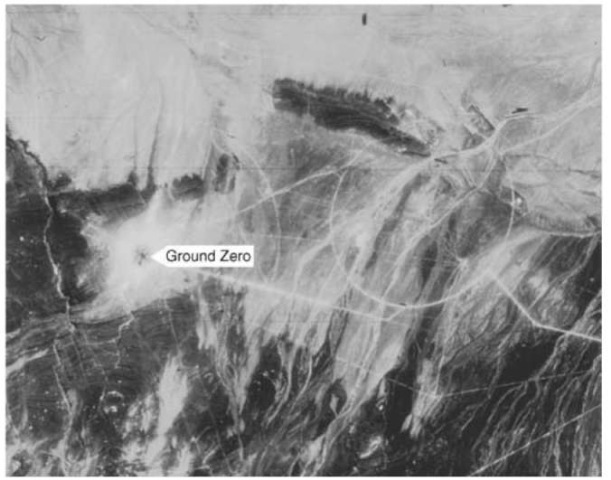
Figure 3. Corona photograph of nuclear test site at Lop Nor, China.
In 1971, Dr. John L. McLucas, the director of the NRO, decided to declassify the meteorological program because it had been producing weather photographs used in the Vietnam War that had been circulated widely. At that time, it was named the Defense Meteorological Satellite Program (DMSP). The Deputy Director of the NRO, Dr. F. Robert Naka (author of this article), resisted attempts by the contractor to add more capability to the satellite by arguing that a simpler system that met the needs of the NRO would be more reliable. The fundamental need of the NRO was to forecast cloud cover. That meant existing cloud cover and the direction of the winds and also measuring and calculating the vertical profile of the temperature and moisture to predict the formation of clouds. By the time the declassification process was completed and the organization was staffed for the use of the civil community in 1973, the DMSP (Fig. 4) and the existing low altitude civil program were essentially the same. The two programs were combined in the late 1990s.
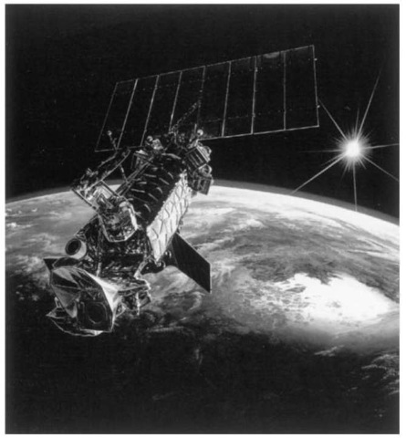
Figure 4. DMSP weather satellite.
GRAB Operations: Signals Collection. The second covert satellite reconnaissance program to be approved by President Eisenhower for full-scale development in August 1959 was the Galactic Radiation and Background (GRAB) program (11). He approved it for launch on 5 May 1960, just five days after the U-2 was shot down by the Soviet Union. It was successfully launched on a Thor Able rocket from Cape Canaveral on 22 June 1960 piggybacked with the Navy’s third Transit navigation satellite. GRAB (Fig. 5) was placed into a 373 x 748 km orbit at an inclination of 51.3°. The mission lasted 10 months and eventually ended when the spin stabilization was slowed down by Earth’s gravitational field. Thus, it became the first operational satellite of the NRO, although not the first reconnaissance launch to be attempted. GRAB had two payloads: one to measure radar signals in the 3000 MHz S-band from the Soviet Union and the second to measure solar radiation (SolRad). The second mission was disclosed to the public. Both payloads were designed and produced by the Naval Research Laboratory. The ELINT payload successfully collected the signals from many more Soviet air defense radars than had been anticipated.
SUPPORT TO MILITARY FORCES
Launch Detection and Space Surveillance. The concept that a satellite-borne infrared sensor array could detect and report the launch of an ICBM and thereby provide 30 minutes warning was strongly supported by the military officers of the Strategic Air Command and the U.S. Air Force. The ground-based Ballistic Missile Early Warning System (BMEWS) could provide only 15 minutes warning, so the additional 15 minutes would permit launching more manned bombers from their air bases where they would be less vulnerable to a nuclear weapon burst. On the other hand, the civilian executives in the Pentagon were skeptical that the system could be made to work. More precisely, they were skeptical that the sensor array would have enough sensitivity and if it did, they thought that the background would produce false alarms.
Credit for pushing the idea of the Missile Detection and Alarm System (MIDAS) is given to Joseph J. Knopow employed by the Lockheed Aircraft Corporation in Van Nuys, California. MIDAS was the forerunner of the Defense Support Program (DSP, Figs. 6 and 7) (12). Both had passive infrared detectors that operated at a wavelength of 2.7 mm and could sense the radiation from a burning rocket plume. Here the similarity ends. MIDAS originally operated at a low Earth orbit (LEO) of 260 miles altitude whereas DSP, that is still operational today, operates at geosynchronous Earth orbit (GEO) at an altitude of 22,500 miles. There are even greater differences because the developers of MIDAS suffered from an immature technology that resulted in many launch failures coupled with in-orbit payload failures, even when the launch succeeded. The first attempted launch on 26 February 1960 ended in failure.
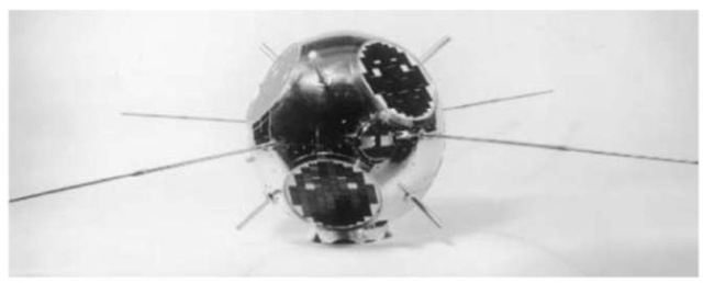
Figure 5. GRAB signals collection satellite.
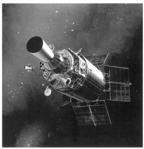
Figure 6. DSP satellite.
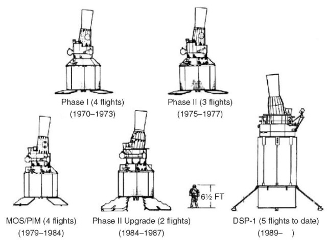
Figure 7. DSP configurations for various block changes.
In June 1956, Lockheed Missiles and Space Division was selected as the prime contractor. MIDAS never left the research and development phase, so that there was no full-scale development decision. Rather, the emphasis was on gathering sensitivity data and on making the system work. MIDAS had four series; each had two to four spacecraft. Series IV was intended as a prototype but was cancelled. The spacecraft were numbered sequentially irrespective of the Series. Not until MIDAS 7, the second of Series III, launched on 9 May 1963, was total success achieved. The spacecraft operated for 6 weeks. The capability of the concept was 50 kW/srad, and the background produced no false alarms. Series I and III had Aerojet sensors, and those of Series II were built by Baird Atomic. Series III had more capability than Series II, and Series II more than Series I. Series I had 27 detectors spinning at 2rpm, whereas Series III had 184 lead sulfide detectors spinning at 6 rpm at an altitude of 2000 nm.
In the late spring of 1963, Project Forecast was convened to recommend promising new concepts and technologies for the Air Force. General Bernard Schriever and Dr. Allen Puckett led the study. The success of MIDAS 7 encouraged expansive thinking. The Surveillance Panel recommended that it was time to think of putting MIDAS technology into geosychronous Earth orbit (GEO) (13). In January 1968, a study, ”Surveillance of Objects in Space in the 1970s” was initiated jointly for General James Ferguson, Commander Air Force Systems Command and for General Arthur Agan, Commander Aerospace Defense Command, and directed by the author (14). The Study recommended detecting ICBM launches by using a DSP-like system that was called High Altitude Surveillance Platform (HASP) and passive Long Wavelength Infra Red detector system (8-14 mm) in LEO called Low Altitude Surveillance Platform (LASP) to catalog objects in space and differentiate them from nuclear warhead reentry vehicles and decoys. During the Strategic Defense Initiative (SDI), the LASP concept was changed and called the Space Surveillance and Tracking System, now called Space Based Infra Red System (SBIRS) Low. SBIRS Low follows the SDI concept of cueing from DSP (now called SBIRS High) and tracking those objects, so it has a narrow field of view that does not permit the broad space surveillance proposed for LASP. Communications. This section contains a brief discussion of military space communications. There is a more extensive discussion of communication satellites elsewhere in this topic. This section first describes the differences between military and civil communications systems, then three military satellite communications programs, roughly in the order in which they were approved for development and acquisition, although the reader will note that the programs ran concurrently. They are the Defense Satellite Communications System for long-haul communications, the Tactical Satellite Communications System for tactical communications, and Milstar for strategic communications.
Military communications that employ Earth satellite relays are similar to their civil counterparts, but military satellites have one distinctive difference. Military communications must be able to operate before, during, and after a military conflict. They must be designed to withstand intentional enemy interference, or “jamming,” as well as unintentional interference. The uplink from ground to satellite is susceptible to enemy jamming because a determined adversary can generate considerable power and employ a large antenna at any location within the uplink coverage area of the beam on Earth. The countermeasure for this is to have a large bandwidth system that employs frequency-hopping, or spread spectrum signals, to force the adversary to broadband noise jamming that dilutes the effort. This countermeasure favors higher operating frequencies because radio-frequency component bandwidths are generally 10% of the operating frequency. The downlink is somewhat less susceptible to jamming because it is the ground or airborne receiving terminal that must be jammed, so that main beam jamming is usually not possible. Side-lobe jamming requires a factor of about 1000 (30 decibels) in power density greater than that needed for main beam jamming. On the other hand, satellite power is limited by what can be generated in space. To offset this weakness, multiple narrow beams are employed in the satellite that again favors higher operating frequencies. Hence, there is a trend from ultrahigh frequency (UHF) in the military band from 225^400 MHz toward extremely high frequency (EHF) in the military band from 20,000^4,000 MHz.
There is also a need to transmit classified messages either for military operations or other sensitive data such as intelligence that will require message encryption. In the civil community, there is a similar need to transmit banking, credit, and currency data, but much of that traffic is carried by fiber-optic cable. On the other hand, military communications, must be available worldwide where often fiber-optic cable communications are not available, such as in much of Africa. Nevertheless, in 1994, the Air Force Scientific Advisory Board recommended that the Air Force make more use of fiber-optic cable communications instead of satellite communications, whenever it is available (15). In many instances, the life-cycle cost of fiber-optic communications is less, even for transoceanic communications.
The fact that commercial companies had laid the fiber was not a problem for the military services. The Department of Defense (DoD) has often leased private networks for its classified operational message traffic and used commercial networks for its routine traffic.
A similar situation occurred in using satellite communications. As military satellite communications developed, there was a tendency to put all military traffic on dedicated DoD networks. However, that capacity was found insufficient during the Vietnam War, so routine traffic was again carried by commercial satellite carriers. That decision reestablished the policy that had been in effect when there were only landlines for communications.
Using those facts as preamble, the first military satellite communications project was called Advent and was assigned to the U.S. Army for development. There were prior activities that are described in the literature (16). Advent suffered through the same research and development problems that plagued space programs in general: immature technology led to delays and cost overruns. That in turn led to criticism by senior executives, such as the Secretary of Defense, and by the members of Congress and caused program cancellations. In the case of Advent, Defense Secretary McNamara cancelled the Program on 23 May 1962. Before that date in May 1960, the strategic, as opposed to tactical, communications of the three services were combined into the Defense Communications System (DCS) and were assigned to the newly created Defense Communications Agency (DCA). On 15 July 1964, Secretary McNamara approved a system for full-scale development that The Aerospace Corporation had been studying for the Air Force (17,18) and thereby approved a dedicated military system that the Air Force had favored over a commercial joint use civil and military system. A joint use system is not necessarily ideal because the civil users are always suspicious of any military incursions into their domains. Conversely, the military are uneasy about the reliability and security of civil systems.
The new system was called the Initial Defense Communications Satellite Program (IDCSP). The satellites were to weigh 100 pounds each and would be launched up to eight at a time in near synchronous circular orbits by a Titan IIIC booster. The Air Force was given responsibility for the satellites and boosters, and the Army was given responsibility for the ground terminals. The first seven satellites were launched on 16 June 1966, operating in the super high frequency (SHF) band of 8-9 GHz. A total of 26 satellites was successfully launched by 13 June 1998. Each satellite had a 24-face polyhedron that contained a total of 8,000 solar cells. This was sufficient to power either 11 tactical quality or five commercial quality voice circuits or 1550 teletype symbols per second. Alternatively, each satellite could relay about 1,000,000 bits of digital data per second. DCA declared the system operational before the launch of the last group of satellites and changed the name to Initial Defense Satellite Communications System (IDSCS). The satellite’s mean time before failure turned out to be 6 years although the design life had been 3 years. As the shortcomings of IDSCS were remedied by advanced systems, it became known as DSCS I (Fig. 8).
A DSCS II satellite constellation was to consist of four satellites in geosynchronous orbit plus two orbiting spares. Each satellite was larger than DSCS I at 2.7 m in diameter and 4 m high, when antennae were extended, and weighed 590 kg. It was dual spun and could support 1300 two-way voice channels or 100 million bits of digital data per second. The first pair was launched on 2 November 1971. The remaining history is somewhat spotty because of the now usual booster failures and also payload failures. By the early 1980s, however, the constellation had fulfilled the DoD’s need by linking 46 strategic ground terminals and 31 mobile forces ground terminals and also served 52 terminals of the Diplomatic Telecommunications System. In addition, DSCS B4 launched 13 December 1973 lasted four times its design life and was turned off on 13 December 1993.
DSCS III finally came close to the operational needs of the armed forces by having separate electronically switched SHF multiple beam antennae for transmission and reception, as well as UHF and SHF Earth coverage antennae. Antijam capability was provided by the antenna diversity. Naturally, each satellite was heavier and larger, but its main difference was that it was three-axis stabilized.
The tactical system or TACSATCOM at ultrahigh frequencies (UHF) in the 225-400 MHz band is the responsibility of the U.S. Navy. It is worth noting that all military aircraft are equipped with UHF radios, so this a very important program, even though aircraft may not be equipped to communicate with satellites. Of the three systems described here, UHF radios are the most susceptible to jamming.
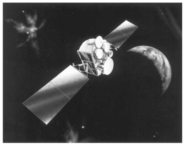
Figure 8. DSCS satellite.
The triservice Tactical Satellite Communications Program 591 was established in 1965 by the DoD to enable the Army, Navy, and Air Force to determine the potential usefulness of UHF satellite communications. The Lincoln Laboratory of the Massachusetts Institute of Technology was chosen to develop the experimental satellites for the test program (19,20). Lincoln Experimental Satellite (LES) 5 was to be launched as soon as possible, and LES-6 was to be launched a year later incorporating improvements. LES-5 was launched on 1 July 1967 on a Titan III-C and LES-6 on 28 September 1968. LES-5 was placed into a subsynchronous equatorial orbit and drifted eastward at 33° per day. The tests of Army, Navy, and Air Force ground, sea, and air units met their performance goals, and the system was put into production. To complete a worldwide communications system, a number of satellites have been put into orbit over the years. They are TACSAT in 1969, three Gapfiller/GAPSATs in 1976, six FLTSATCOMs in 1978 to 1989, four LEASATs in 1984, and 10 UHF Follow-on (UFO) satellites in 1993 to 1998. UFO F-11 is scheduled for launch in year 2004, the Mobile User Objective System is in program definition, and is expected to be operational in 2007.
The UFO program has more than an improved UHF capability. Flight vehicles F-1 through F-3 had an SHF payload as well, an UHF F-4 through F-7 had EHF in addition, and F-8 through F-10 have a Global Broadcast System (GBS) instead of the SHF payload. The GBS is to broadcast intelligence information to deployed U.S. Forces (15). Thus the UFO satellites have an expanded capability to support, simultaneously, multiple users in several military bands.
The strategic system, the responsibility of the Air Force, was called Stratcom, now Milstar. It operates at extremely high frequencies (EHF) of 20 GHz (for the downlink) and 44 GHz (for the uplink) and is closer to an ultimate system in that it is robust. Its wide bandwidth would make jamming very difficult and smaller ground terminals could be supported. However, the issue of backward compatibility has caused Milstar to carry also both SHF for long haul communications and UHF payloads for tactical users. To support this wide array of users, a 60 GHz cross-link is available between the geosynchronous altitude satellites. The result was a Milstar I satellite (Fig. 9) weighing 10,000 pounds that required a Titan IV booster to launch it rather than a medium launch vehicle. To keep the weight down, the highly protected individual channel satellite capability has a low data rate of only 2.4 kbps. Milstar II will increase that capability to 1.544 Mbps. There are currently two Milstar I satellites in orbit, F-1 launched on 7 February 1994 and F-2 on 6 November 1995. The first launch of Milstar II, F-3, failed in May 1999. The second launch, F-4, is planned during
2001.
Navigation. This section describes the development of satellite-borne navigation systems by the Department of Defense. There is a more thorough discussion elsewhere in this topic. This section describes the differences between military and civil navigation systems and the development of the Global Positioning System (GPS) by the Department of Defense. It also describes the measures taken to ensure that use of GPS by the enemy in the war zone will be ineffective and enemy attempts to disrupt U.S. use of GPS can be frustrated.
There are two major differences between military and civil systems that should be discussed. The first is jamming, attempted deliberate interruption of the system by an enemy in a war zone. The second is the need for our forces to interrupt civil GPS receivers being used by the enemy in the war zone, a process called “denial.” The denial process should not disrupt civil uses of GPS in a country adjacent to the war zone.
Accurate position location and navigation are at the heart of many activities, not only for both the military and civil communities. The navies and merchant marines of the nations require accurate navigation to reach their desired locations. It is not surprising, therefore, that the first navigation satellite system, Transit, was put into operation by the U.S. Navy in 1964 and is still in use today (21). This satellite was designed by personnel at the Applied Physics Laboratory of the Johns Hopkins University. A follow-up program called Timat-ion, built by the Naval Research Laboratory, proved the ability to operate atomic clocks in orbit. That was used as a system concept for the Global Positioning System. Program 621B was a study conducted by the Aerospace Corporation in 1964 for the Air Force Space and Missile Systems Organization. In 1972, the best characteristics were assembled for a new system called NAVSTAR Global Positioning System. The system was developed and built for the U.S. Air Force that operates and controls it from a ground station at Schriever Air Force Base, near Colorado Springs, Colorado. The space portion is comprised of 24 satellites, 4 each in 6 planes. Each satellite knows its own ephemeris and the time, so that it knows its position at all times.
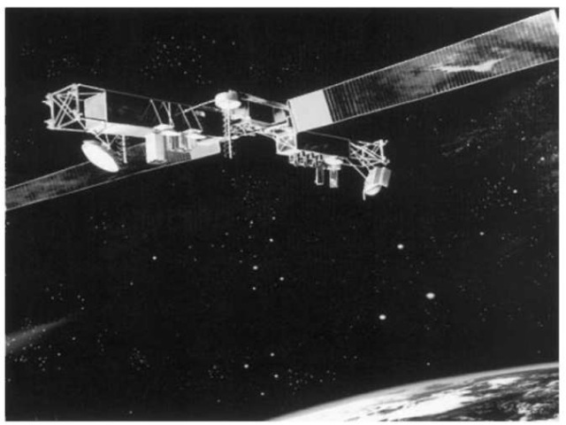
Figure 9. Milstar satellite.
Military and civil position locations require a number of similar and essentially identical activities but also serve vastly different ones. Both communities would like to land aircraft on a runway under conditions of very poor visibility, preferably automatically without human intervention. At the other extreme is the military desire to lay bombs on military targets very accurately, employing small bombs that destroy the targets but leave adjacent structures and people unaffected. The recent bombing of buildings in Belgrade, Serbia, by forces of the North Atlantic Treaty Organization is a case in point. This great accuracy was made possible by GPS. This pinpoint accuracy contrasted sharply with what was possible during the Vietnam War, when it was impossible to destroy a bridge using conventional bombs dropped from B-52 bombers from high altitude.
As implied by the last Navy system, Timation, the exact time that is carried by all elements of the navigation system, is the most important factor. All GPS satellites (Fig. 10) carry either rubidium or cesium clocks, or both. These have an accuracy of about 10 nanoseconds that corresponds to an accuracy of 10 feet. The U.S. Naval Observatory has installed a hydrogen maser clock that has an accuracy of one picosecond at the ground control station at Schriever Air Force
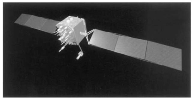
Figure 10. GPS satellite.
Base. If this accurate time could be transmitted routinely to the satellites for retransmission and a system error of a factor of 100 were adopted, the accuracy of the entire system could be improved to one inch!
