Geoscience Reference
In-Depth Information
1
2
3
4
5
6
7
8
9
10
11
12
13
14
15
16
17
18
19
20
21
22
23
24
25
26
27
28
29
30
31
32
33
34
35
36
37
38
39
40
41
42
43
44
45
46
47
48
49
2
Close to the trough line
: well-developed cumulus,
occasional showers, improving visibility.
3
Behind the trough
: veer of wind direction, heavy
cumulus and cumulonimbus, moderate or heavy
thundery showers and a decrease of temperature.
Satellite photography indicates that the classical
easterly wave is less common than was once supposed.
Many Atlantic disturbances show an 'inverted V' wave
form in the low-level wind field and associated cloud,
or a 'comma' cloud related to a vortex. They are often
apparently linked with a wave pattern on the ITC further
south. West African disturbances that move out over the
eastern tropical Atlantic usually exhibit low-level
confluence and upper-level diffluence ahead of the
trough, giving maximum precipitation rates in this same
sector. Many disturbances in the easterlies have a closed
cyclonic wind circulation at about the 600 mb level.
It is difficult to trace the growth processes in wave
disturbances over the oceans and in continental areas
with sparse data coverage, but some generalizations
may be made. At least eight out of ten disturbances
develop some 2 to 4° latitude poleward of the equatorial
trough. Convection is set off by convergence of mois-
ture in the airflow, enhanced by friction, and maintained
by entrainment into the thermal convective plumes
(see Figure 11.3). Some ninety tropical disturbances
develop during the June to November hurricane season
in the tropical Atlantic, about one system every three to
five days. More than half of these originate over Africa.
According to N. Frank, a high ratio of African depres-
sions in the storm total in a given season indicates
tropical characteristics, whereas a low ratio suggests
storms originating from cold lows and the baroclinic
zone between Saharan air and cooler, moist monsoon
air. Many of them can be traced westward into the
eastern North Pacific. Out of an annual total of sixty
Atlantic waves, 23 per cent intensify into tropical
depressions and 16 per cent become hurricanes.
Developments in the Atlantic are closely related
to the structure of the trades. In the eastern sectors of
subtropical anticyclones, active subsidence maintains
a pronounced inversion at 450 to 600 m (Figure 11.5).
Thus the cool eastern tropical oceans are characterized
by extensive, but shallow, marine stratocumulus, which
gives little rainfall. Downstream the inversion weakens
and its base rises (Figure 11.6) because the subsidence
decreases away from the eastern part of the anticyclone
and cumulus towers penetrate the inversion from time
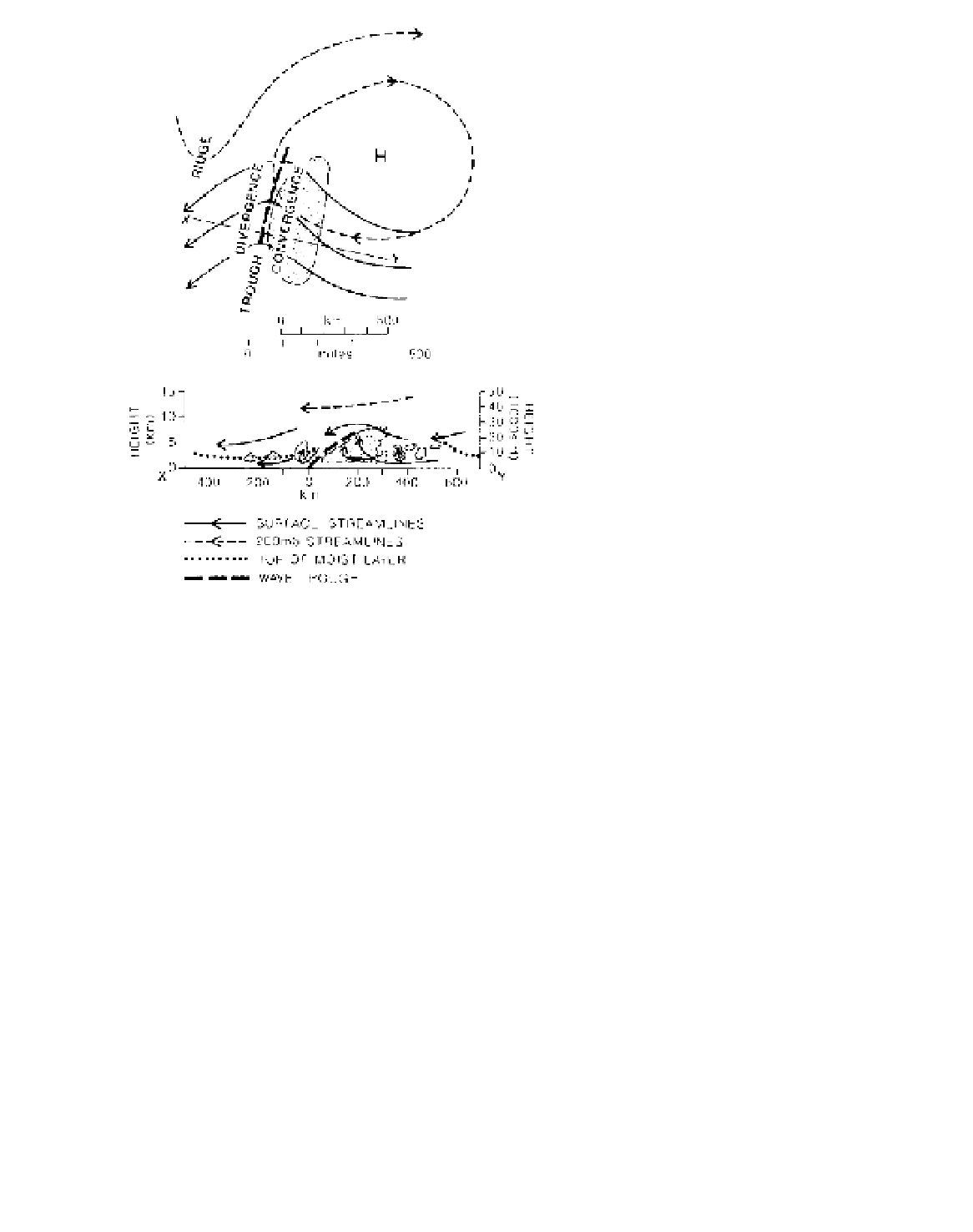
Figure 11.4
A model of the areal (above) and vertical (below)
structure of an easterly wave. Cloud is stippled and the pre-
cipitation area is shown in the vertical section. The streamline
symbols refer to the areal structure, and the arrows on the vertical
section indicate the horizontal and vertical motions.
Source
: Partly after Malkus and Riehl (1964).
Conversely, there is divergence in the air moving south-
ward ahead of the trough and curving anticyclonically.
The true divergent zone is characterized by descending,
drying air with only a shallow moist layer near the
surface, while in the vicinity of the trough and behind it
the moist layer may be 4500 m or more deep. When the
easterly airflow is slower than the speed of the wave,
the reverse pattern of low-level convergence ahead
of the trough and divergence behind it is observed as a
consequence of the potential vorticity equation. This
is often the case in the middle troposphere, so that
the pattern of vertical motion shown in Figure 11.4 is
augmented.
The passage of such a transverse wave in the trades
commonly produces the following weather sequence:
1
In the ridge ahead of the trough
: fine weather,
scattered cumulus cloud, some haze.