Geoscience Reference
In-Depth Information
represented by the planetary-scale waves. The planetary
waves (with a wavelength from 10,000 to 40,000 km)
need not concern us in detail here. Two types occur in
the equatorial stratosphere and another in the equatorial
upper troposphere. While they may interact with lower
tropospheric systems, they do not appear to be direct
weather mechanisms. The synoptic-scale systems that
determine much of the 'disturbed weather' of the tropics
are sufficiently important and varied to be discussed
under the headings of wave disturbances and cyclonic
storms.
1 Wave disturbances
Several types of wave travel westward in the equatorial
and tropical tropospheric easterlies; the differences
between them probably result from regional and
seasonal variations in the structure of the tropical atmos-
phere. Their wavelength is about 2000 to 4000 km, and
they have a life span of one to two weeks, travelling
some 6 to 7° longitude per day.
The first wave type to be described in the tropics was
the easterly wave of the Caribbean area. This system is
quite unlike a mid-latitude depression. There is a weak
pressure trough, which usually slopes eastward with
height (Figure 11.4). Typically the main development
of cumulonimbus cloud and thundery showers is
behind the trough line. This pattern is associated with
horizontal and vertical motion in the easterlies. Behind
the trough, low-level air undergoes convergence, while
ahead of it there is divergence (see Chapter 6B.1). This
follows from the equation for the conservation of
potential vorticity (cf. Chapter 9G), which assumes that
the air travelling at a given level does not change its
potential temperature (i.e. dry adiabatic motion; see
Chapter 5A):
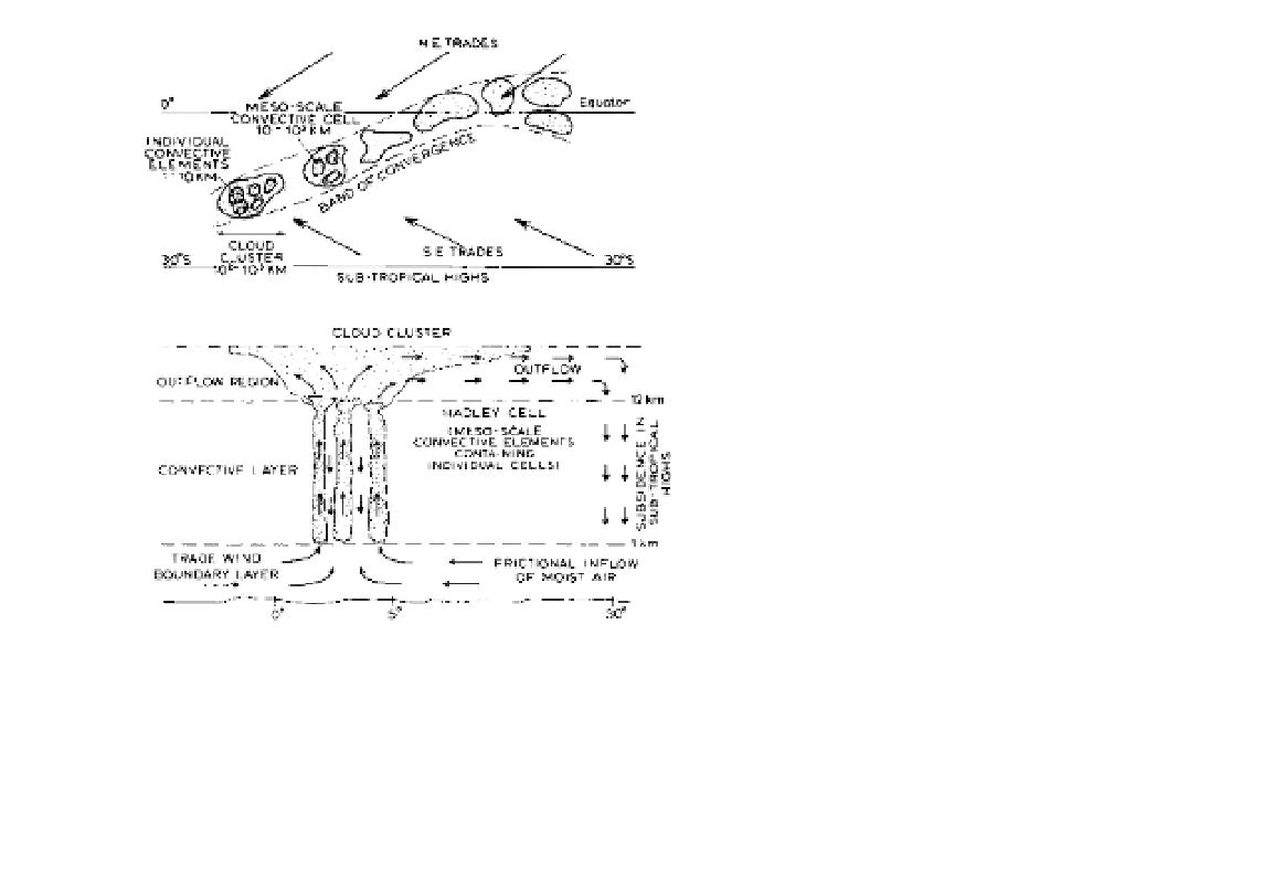
Figure 11.3
The mesoscale and synoptic structure of the
equatorial trough zone (ITCZ), showing a model of the spatial
distribution (above) and of the vertical structure (below) of
convective elements which form the cloud clusters.
Source
: From Mason (1970), by permission of the Royal Meteorological
Society.
is most extensive through the spreading of cirrus
canopies. Clusters in the Atlantic, defined as more than
50 per cent cloud cover extending over an area of 3°
square, show maximum frequencies of ten to fifteen
clusters per month near the ITC and also at 15 to 20°N
in the western Atlantic over zones of high sea-surface
temperature. They consist of a cluster of mesoscale
convective cells with the system having a deep layer
of convergent airflow (see Figure 11.3). Some persist
for only one to two days, but others develop within
synoptic-scale waves. Many aspects of their devel-
opment and role remain to be determined. While
convection has been stressed, studies in the western
equatorial Pacific 'warm pool' region indicate that large
rain areas in cloud clusters consist mainly of stratiform
precipitation. This accounts for over 75 per cent of the
total rain area and for more than half of the rain amount.
Moreover, the cloud systems are not 'warm clouds'
( p. 102) but are made up of ice particles.
The fourth category of tropical weather system
includes the synoptic-scale waves and cyclonic vortices
(discussed more fully below) and the fifth group is
——— = k
∆
ƒ
p
where
f
= the Coriolis parameter,
= relative vorticity
(cyclonic positive) and ∆p = the depth of the tropos-
pheric air column. Air overtaking the trough line is
moving both poleward (f increasing) and towards a
zone of cyclonic curvature (
increasing), so that if the
left-hand side of the equation is to remain constant ∆p
must increase. This vertical expansion of the air column
necessitates horizontal contraction (convergence).