Geoscience Reference
In-Depth Information
prevalence of snow and ice surfaces. These factors con-
trol the surface energy budget regimes and low annual
temperatures (see Chapter 10B). The polar regions are
also energy sinks for the global atmospheric circulation
(see Chapter 7C.1), and in both cases they are overlain
by large-scale circulation vortices in the middle tropos-
phere and above (see Figures 7.3 and 7.4). In many other
respects, the two polar regions differ markedly because
of geographical factors. The north polar region com-
prises the Arctic Ocean, with its almost year-round sea
ice cover (see Plate A), surrounding tundra land areas,
the Greenland Ice Sheet and numerous smaller ice-caps
in Arctic Canada, Svalbard and the Siberian Arctic
Islands. In contrast, the south polar region is occupied
by the Antarctic continent, with an ice plateau 3 to 4 km
high, floating ice shelves in the Ross Sea and Weddell
Sea embayments, and surrounded by a seasonally ice-
covered ocean. Accordingly, the Arctic and Antarctic
are treated separately.
a The Arctic
At 75°N, the sun is below the horizon for about ninety
days, from early November until early February. Winter
air temperatures over the Arctic Ocean average about
-32°C, but they are usually 10-12°C higher some 1000
m above the surface as a result of the strong radiative
temperature inversion. The winter season is generally
stormy in the Eurasian sector, where low-pressure
systems enter the Arctic Basin from the North Atlantic,
whereas anticyclonic conditions predominate north of
Alaska over the Beaufort and Chukchi seas. In spring,
high pressure prevails, centred over the Canadian Arctic
Archipelago-Beaufort Sea.
The average 3 to 4 m thickness of sea ice in the Arctic
Ocean permits little heat loss to the atmosphere and
largely decouples the ocean and atmosphere systems in
winter and spring. The winter snow accumulation on
the ice averages 0.25 to 0.30 m depth. Only when the ice
fractures, forming a
lead
, or where persistent offshore
winds and/or upwelling warm ocean water form an area
of open water and new ice (called a
polynya
), is the
insulating effect of sea ice disrupted. The ice in the
western Arctic circulates clockwise in a gyre driven by
the mean anticyclonic pressure field. Ice from the
northern margin of this gyre, and ice from the Eurasian
sector, moves across the North Pole in the Transpolar
Drift Stream and exits the Arctic via Fram Strait and the
East Greenland current (see Figure 10.35A). This export
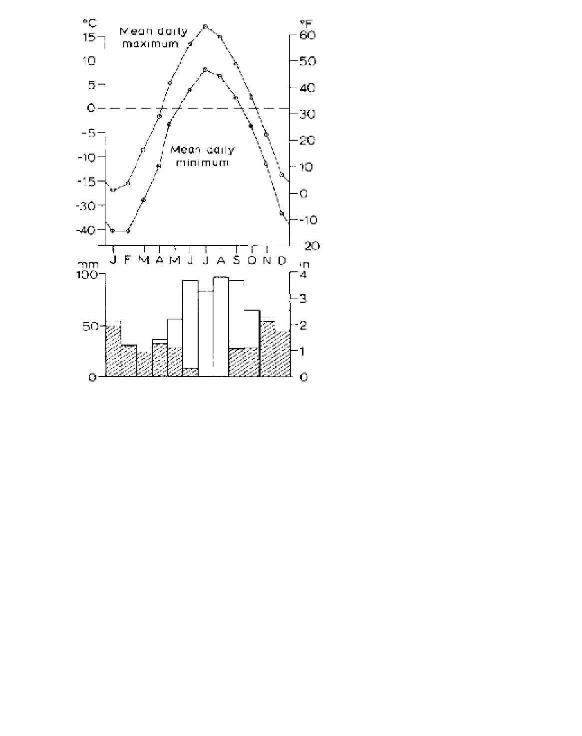
Figure 10.36
Selected climatological data for McGill Sub-Arctic
Research Laboratory, Schefferville, PQ, 1955 to 1962. The
shaded portions of the precipitation represent snowfall, expressed
as water equivalent.
Source
: Data from J. B. Shaw and D. G. Tout.
have exceeded 4°C during incursions of maritime
Atlantic air. Such variability is not found in eastern
Siberia, which is intensely continental, apart from the
Kamchatka Peninsula, with the northern hemisphere's
cold pole
located in the remote northeast (see Figure
3.11A). Verkhoyansk and Oimyakon have a January
mean of -50°C, and both have recorded an absolute
minimum of -67.7°C. Stations located in the valleys of
northern Siberia record, on average, strong to extreme
frosts 50 per cent of the time during six months of the
year, but very warm summers (Figure 10.37).
3 The polar regions
Common to both polar regions is the semi-annual
alternation between polar night and polar day, and the