Geoscience Reference
In-Depth Information
In the Maritimes it is related to winter (and also
autumn) storm tracks.
highlight varaition in the dry regions of the country.
The boundary separating the moist climates of the east,
where the ratio AE/PE exceeds about 8 per cent or more,
from the dry climates of the west (excluding the west
coast), follows the 95th meridian. The major humid
areas are along the Appalachians, in the northeast
and along the Pacific coast, while the most extensive
arid areas are in the intermontane basins, the High
Plains, the southwest and parts of northern Mexico.
In the west and southwest the ratio is small due to lack
of precipitation, whereas in northwest Canada actual
evaporation is limited by available energy.
It is worth comparing the eastern regime with the
summer maximum that is found over East Asia, where
the Siberian anticyclone excludes cyclonic precipitation
in winter and monsoonal influences are felt in the
summer months.
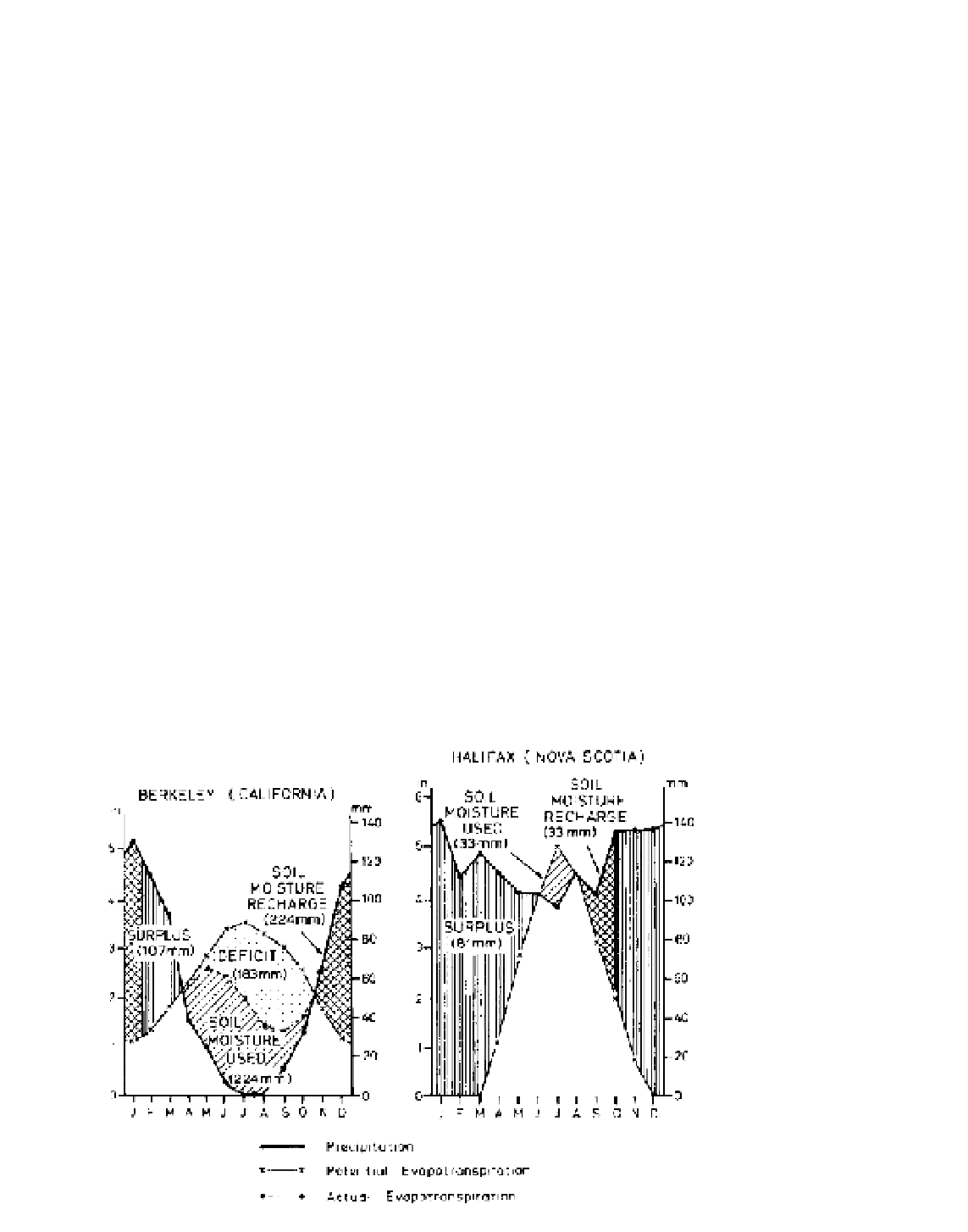
The seasonal distribution of precipitation is of
vital interest for agricultural purposes. Rain falling in
summer, for instance, when evaporation losses are high,
is less effective than an equal amount in the cool season.
Figure 10.22 illustrates the effect of different regimes
in terms of the moisture balance, calculated according
to Thornthwaite's method (see Appendix 1B). At
Halifax (Nova Scotia), sufficient moisture is stored in
the soil to maintain evaporation at its maximum rate (i.e.
actual evaporation = potential evaporation), whereas at
Berkeley (California) there is a computed moisture
deficit of nearly 50 mm in August. This is a guide to
the amount of irrigation water that may be required
by crops, although in dry regimes the Thornthwaite
method generally underestimates the real moisture
deficit.
Figure 10.23 shows the ratio of actual to potential
evaporation (AE/PE) for North America calculated
by the methods of Thornthwaite and Mather from an
equation relating PE to air temperature. It is drawn to
C THE SUBTROPICAL MARGINS
1 The semi-arid southwestern United States
Both the mechanisms and patterns of the climate in areas
dominated by the subtropical high-pressure cells are
not well documented. The inhospitable nature of these
arid regions inhibits data collection, and yet the study
of infrequent meteorological events requires a close
network of stations maintaining continuous records over
long periods. This difficulty is especially apparent in the
interpretation of desert precipitation data, because much
of the rain falls in local storms irregularly scattered
in both space and time. The climatic conditions in the
southwestern United States serve to exemplify this
Figure 10.22
The moisture balances
at Berkeley, California, and Halifax,
Nova Scotia.
Source
: After Thornthwaite and Mather
(1955).