Geoscience Reference
In-Depth Information
1800m elevation in West Antarctica and 2600m in
East Antarctica, where it rises above 4000m (82
40
S,
75°E). In September, sea ice averaging 0.5-1.0m
in thickness covers 20 million km
2
of the Southern
Ocean, but 80 percent of this melts each summer.
Over the ice sheet, temperatures are almost
always well below freezing. The South Pole
(2800m elevation) has a mean summer tempera-
ture of -28
°
20
0
250
200
HEAT SOURCES
150
100
C.
Vostok (3500m) recorded -89°C in July 1983, a
world record minimum. Mean monthly tempera-
tures are consistently close to their winter value
for the six months between equinoxes, creating a
so-called 'coreless winter' pattern of annual tem-
perature variation (
Figure 10.39
). Atmospheric
poleward energy transfer balances the radiative
loss of energy. Nevertheless, there are considerable
day-to-day temperature changes associated with
cloud cover increasing downward long wave
radiation, or winds mixing warmer air from above
the inversion down to the surface. Over the
plateau, the inversion strength is about 20-25
°
C and a winter temperature of -58
°
Net radiation
50
Sensible heat
from air
0
Sensible heat to
warm snow/soil
Sensible heat
to warm air
Latent heat
melt/evaporate
-50
-100
-150
HEAT SINKS
-200
-250
28
May
1
5
10
15
18
June
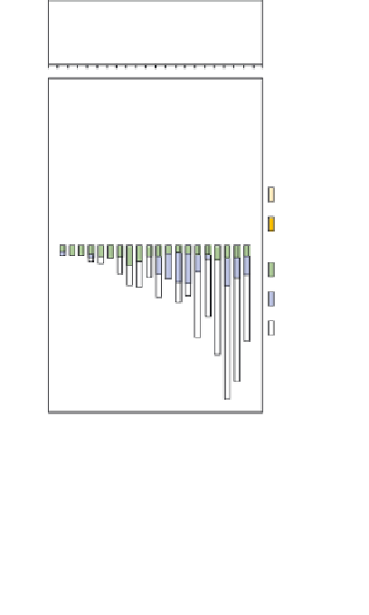
Figure 10.38
The effect of tundra snow cover on
the surface energy budget at Barrow, Alaska,
during the spring melt. The lower graph shows the
daily net radiation and energy terms.
Source: Weller and Holmgren (1974). By permission of the
American Meteorological Society.
C.
Precipitation is almost impossible to measure as
a result of blowing and drifting snow. Snow pit
studies indicate an annual accumulation varying
from less than 50mm over the high plateaux above
3000m elevation to 500-800mm in some coastal
areas of the Bellingshausen Sea and parts of East
Antarctica.
Lows in the southern westerlies have a
tendency to spiral clockwise towards Antarctica,
especially from south of Australia towards the
Ross Sea, from the South Pacific towards the
Weddell Sea, and from the western South Atlantic
towards Kerguelen Island and East Antarctica
(
Figure 10.40
). Over the adjacent Southern Ocean,
cloudiness exceeds 80 percent year-round at
60-65
°
above the equilibrium line altitude (where
accumulation balances ablation), which is at
about 2000m (1000m) elevation in the south
(north) of Greenland. The ice sheet largely creates
its own climate. It deflects cyclones moving from
Newfoundland, either northward into Baffin Bay
or northeastward towards Iceland. These storms
give heavy snowfall in the south and on the
western slope of the ice sheet. A persistent shallow
inversion overlays the ice sheet with downslope
katabatic winds averaging 10m s
-1
, except when
storm systems cross the area.
S (see
Figures 3.8
and
4.13
) due to the
frequent cyclones, but coastal Antarctica has more
synoptic variability, associated with alternating
lows and highs. Over the interior, cloud cover is
generally less than 40-50 percent and half of this
amount in winter.
The poleward air circulation in the tropos-
pheric polar vortex (see
Figure 7.3
) leads to
°
Antarctica
Except for protruding peaks in the Transantarctic
Mountains and Antarctic Peninsula, and the
Dry Valleys of Victoria Land (77
E), over
97 percent of Antarctica is covered by a vast
continental ice sheet. The ice plateau averages
°
S, 160
°