Geoscience Reference
In-Depth Information
(A)
(B)
0
10
-20
8
6
-40
4
Coreless
win
ter
2
-60
0
Jan
Apr
Jul
Month
Oct
Dec
Jan
Apr
Jul
Month
Oct
Dec
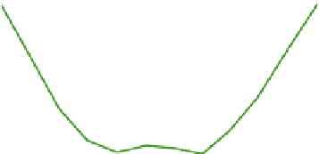
Figure 10.39
Annual course of (A) mean monthly air temperature (°C) and (B) wind speed (m s
-1
) for 1980-1989
at Dome C (3280m), 74.5°S, 123.0°E (plateau) and D-10, an automatic weather station at 240m, 66.7°S, 139.8°E
(coast).
Source: Stearns et al. (1993). By permission of the American Geophysical Union.
subsiding air over the Antarctic Plateau and
outward flow over the ice sheet surface. The winds
represent a balance between gravitational
acceleration, Coriolis force (acting to the left),
friction and inversion strength. On the slopes of
the ice sheet, there are stronger downslope
katabatic flows, and extreme speeds are observed
in some coastal locations. Cape Denison (67°S,
143
90°E
5
0°
0°
180°
E), Adelie Land, recorded average daily wind
speeds of >18m s
-1
on over 60 percent of days in
1912-1913.
°
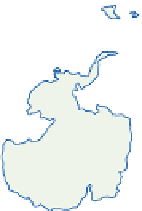
Figure 10.40
Southern Hemisphere cyclone
paths affecting Antarctica and major frontal zones
in winter. 1. Polar Front; 2. Antarctic Front; 3.
Cyclone trajectories.
Source: Carleton (1987). Copyright © Chapman & Hall, New
York. Reproduced by permission.
Indian Ocean
90°W
Polar front
Antarctic front
Cyclone trajectories