Geoscience Reference
In-Depth Information
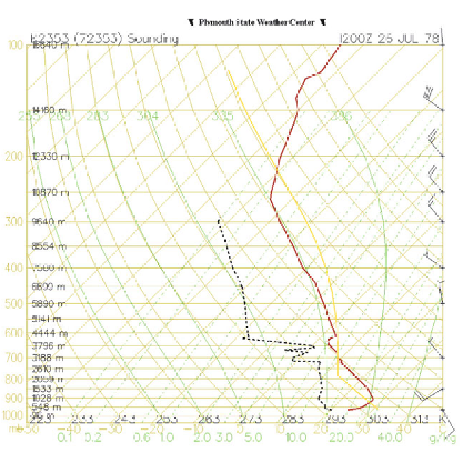
Figure 3.25. Wet-microburst sounding at Oklahoma City, OK at 12:00
utc
on July 26, 1978
(see the storm in Figure 3.22). The notable characteristics of this sounding are the relatively dry
air above 600 hPa and the relatively moist air below 700 hPa. There is thus the potential for a
relative wet convective storm with heavy water loading and dry air being entrained aloft
leading to evaporative cooling aloft.
wet-microburst environment and the non wet-microburst environment is more
dicult. Wet microbursts do not always occur when convective storms are
possible and the LCL/LFC is relatively low. Nolan Atkins and his mentor
Roger Wakimoto at UCLA found that when the difference between the maximum
(usually at or near the surface) and the minimum equivalent potential temperature
in the afternoon is in excess of 20K, wet microbursts are likely. When the
difference is less than or equal to 13K, wet microbursts are unlikely. Such an
empirical finding supports the obvious notion that mixing of dry, cool air aloft in
a storm is conducive to a high evaporation rate, cooling, and production of a
negatively buoyant downdraft, and the cool air aloft supports the formation of ice
particles, which can subsequently melt and cool as they fall into a layer above
freezing.
In the U. S., the Federal Aviation Administration (FAA), with the aid of
work at the MIT Lincoln Laboratory, developed a network of C-band (5 cm
Search WWH ::

Custom Search