Geoscience Reference
In-Depth Information
Table 8.2
Landscape clues to the presence of faults.
Aspect
Typical features
Topography
Break in slope (Figure 8.2a); trough or ridge (Figure 8.2b); scarp; river gorge; abrupt
landscape contrast
Erosion
Ravine/gully/stream/river follows fault-line (easily eroded crushed rock); ridge (if fault
mineralization is harder than country rock; Figure 8.2b)
8
Drainage
Springs, sag ponds (many fault rocks are impermeable; Figure 8.2c); sinkholes (limestone
one side of fault); abrupt drainage contrast at fault
Vegetation
Sharp change across fault, due to soil and/or drainage change on different rock types
(Figure 8.2d)
Offsets
Offset of linear feature (stream, ridge, dyke, road, fence, railway), especially for active faults
(Figure 8.2e)
(
(
(
(
(
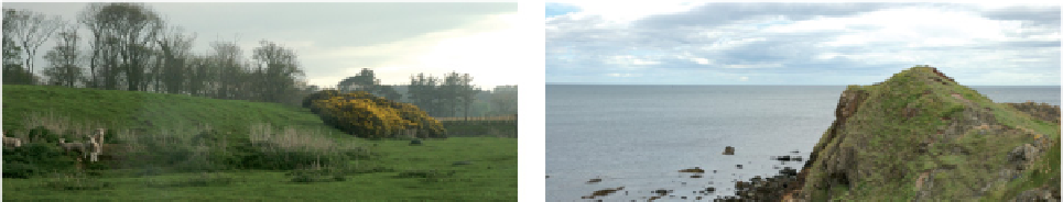
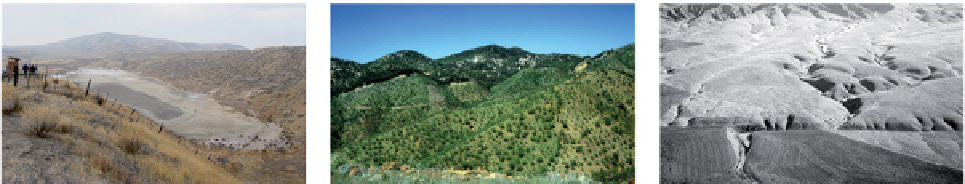
Figure 8.2
Landscape clues to faults. (a) Line of fault runs obliquely from left (just behind lambs) to right,
marked by a break in slope and low scarp (with gorse), northeast England. (b) Hard, mineralized fault rock
forms a ridge
c
. 10 m high along the Highland Boundary Fault, Garron Point, Scotland. (c) A sag pond in a
depression along the San Andreas Fault, Carrizo Plain, California. (d) A steep normal fault (arrowed) marked by
vegetation contrast cuts across topography in southern Spain. (e) Wallace Creek, a stream offset across the San
Andreas Fault (arrowed), California. (a and b: Angela L. Coe, The Open University, UK. c: Courtesy of the U.S.
Geological Survey. d: Tom W. Argles, The Open University, UK. e: Courtesy of the U.S. Geological Survey;
photographer Bob Wallace.)