Geoscience Reference
In-Depth Information
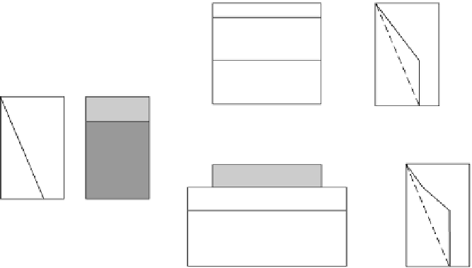
Figure 10.48.
Various
models of lithospheric
extension. (a) Pure shear
extension, as in Fig. 10.44.
(b) Depth-independent
pure-shear extension. The
crust is extended by factor
β
T
a
Temp
h
c
/
β
(a)
Pure shear
h
l
/
β
T
a
, the mantle by a factor
Temp
crust
mantle lithosphere
asthenosphere
δ
). The solid line
denotes temperature
profiles immediately after
extension; the dashed
line, the final equilibrium
temperature profile. (c)
Simple shear extension. A
detachment surface, or
fault, extends right
through the crust and
mantle. For this model,
the extension factors
β
and
δ
vary continually
across the structure, in
contrast to pure-shear
extension, for which they
are constant across the
structure. (After Quinlan
(1988) and Wernike
(1985).)
(
δ>β
h
c
T
a
Temp
h
c
/
β
h
c
/
β
+( - )
h
l
(b)
Depth-dependent
pure shear
h
l
h
c
/
δ
(c)
Simple shear
β
>
δ
β
>
δ
To explain this subsidence satisfactorily, the original crustal thickness beneath
the central graben must have been less than that on either side. This suggests that
there may have been an earlier stretching event in the graben and is consistent
with a Triassic rifting event. Other factors that may have affected subsidence in
the North Sea include the thermal effect of the Iceland 'hotspot' and the presence
of faults that are too small to be resolved by seismic methods (Sect. 4.4).
More complex modifications of this continental-extension model involve
depth-dependent extension - that is, more extension in the lower, more duc-
tile part of the lithosphere than in the upper crustal part (Fig. 10.48(b)) - dyke
intrusion or melt segregation and lateral variation of stretching (Fig. 10.48(c)).
These complex models have been developed to explain why some continental
margins and rift systems apparently exhibit no initial subsidence but some uplift
or doming, and to explain why thermal contraction is insufficient to account for
the maximum depth of the ocean basins. However, the simple one-dimensional
model described here is a reasonable initial approximation to the formation of
many continental margins and basins.
10.3.7 Compressional basins
A striking feature of the gravity field of central Australia is the 600-km sequence
of east-west anomalies with a north-south wavelength of about 200 km. These
Bouguer anomalies range from
−
150 to
+
20 mgal (Fig. 10.49). This part of