Geoscience Reference
In-Depth Information
Earth to a more spherical shape following the removal of the Pleistocene glaciers.
This represents a relative change in moment of inertia of about 10
−
8
yr
−
1
.
5.5 Gravity anomalies
5.5.1 Introduction
Measurements of the gravitational attraction of the Earth are not only useful
for discovering the exact shape of the Earth and its rotational properties; they
also provide information about the structure and properties of the lithosphere
and mantle. Gravity anomalies are very small compared with the mean surface
gravity value of 9.81 m s
−
2
and are therefore often quoted in a more convenient
unit, the
milligal
,which is 10
−
5
ms
−
2
(10
−
3
gal). Another unit that is used is the
gravity unit
, gu, which is 10
−
6
ms
−
2
(1 gu
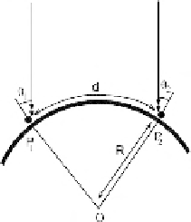
Figure 5.5.
A schematic
diagram showing use of a
plumb line (solid circle
with line) to measure the
distance between two
points on the Earth's
surface (heavy arc).
Dashed line, light from
distant source;
d
, distance
between two points P
1
and P
2
;
R
, radius of the
Earth; and O, centre of the
Earth. Geometry gives
d
=
R
(
θ
1
+
θ
2
). In India,
Everest found, on
measuring 600 km along a
line of longitude, that the
value obtained using the
plumb-line method was
162 m different (the
normal error was ±5 m).
He thought that this
difference was due to
deflection of the plumb
line from the vertical by
the attraction of the
Himalayas.
10
−
1
mgal). Gravimeters have a sen-
sitivity of about 10
−
5
gal (10
−
2
mgal), or about 10
−
8
of the surface gravitational
acceleration. John Milne (1906)gaveaninteresting example of an anomaly:
=
When a squad of 76 men marched to within 16 or 20 feet of the Oxford University
Observatory it was found that a horizontal pendulum inside the building measured
a deflection in the direction of the advancing load...
5.5.2 Isostasy
Between 1735 and 1745 a French expedition under the leadership of Pierre
Bouguer made measurements of the length of a degree of latitude in Peru and near
Paris in order to determine the shape of the Earth. They realized that the mass
of the Andes mountains would attract their plumb line but were surprised that
this deflection was much less than they had estimated. In the nineteenth century,
the Indian survey under Sir George Everest (after whom the mountain is named)
found the same reduced deflection near the Himalayas (Fig. 5.5). Archdeacon
J. H. Pratt estimated the deflection of a plumb line by the mountains and found
that it should be three times greater than observed. This is now known to be
afairly common attribute of surface features. In 1855, Pratt and Sir George
Airy proposed two separate hypotheses to explain these observations; and, in
1889, the term
isostasy
was first used to describe them. Both for the Himalayas
and for the Andes, the lack of mass or mass deficiency beneath the mountain
chains, which is required in order to account for the reduced deflection of the
plumb lines, was found to be approximately equal to the mass of the mountains
themselves. This is an alternative statement of Archimedes' principle of hydro-
static equilibrium: a floating body displaces its own weight of water. A mountain
chain can therefore be compared with an iceberg or cork floating in water. Thus,
isostasy requires the surface layers of the Earth to be rigid and to 'float' on, or
in, a denser substratum. The rigid surface layer is termed the
lithosphere
and the
region beneath, the
asthenosphere
(Section 2.1); recall that these layers are distinct