Geoscience Reference
In-Depth Information
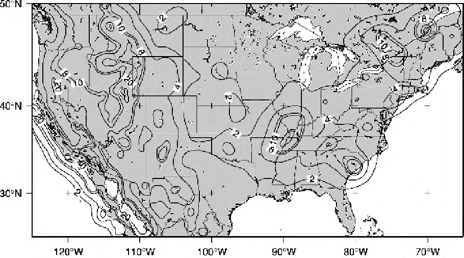
Figure 4.13.
The earthquake-hazard map for the U.S.A. The ground acceleration
(caused by earthquakes) that has a 10% probability of being exceeded in the next
50 years is shown as a percentage of gravity. The highest values are along the west
coast with the San Andreas Fault system and the Cascadia subduction zone, but
note that some areas in the east also have high values. Colour version Plate 4. See
Plate 3 for the global seismic hazard map. (Data from Global Seismic Hazard
Assessment Program: http://seismo.eth2.ch/GSHAP/ and USGS.)
Prediction of earthquakes is seen by some as the ultimate goal of earthquake
research. However, prediction is of little value and is probably dangerous unless
it is able to indicate with a reasonable probability both when and where an
earthquake of a particular magnitude will occur. A predicted earthquake that
then does not happen is a major social, political and economic problem. Present
understanding is such that we have quite good knowledge of where earthquakes
occur, although for very large infrequent earthquakes our knowledge of historical
earthquakes is insufficient (Section 9.6.3), but reliable prediction of time and of
magnitude is not yet attainable. Many approaches have been used to investigate
and monitor the build-up of strain and its sudden release in an earthquake -
these include monitoring of the deformation of the ground surface, recording
microseismic activity, detecting changes in seismic P- and S-wave velocities,
monitoring of changes in the local geomagnetic field and in the electrical resis-
tivity of the upper crust and geochemical monitoring of groundwater and radon
(a product of the decay of uranium in the crust). A section of the San Andreas
Fault system near Parkfield, California, which has had a regular series of identical