Geoscience Reference
In-Depth Information
reflects a period when the Fens were drained well enough to allow the growth of wood-
land with trees of this size.
Landscape D: Early Cretaceous Fenland foothills
Bedrock of Early Cretaceous age rests upon Late Jurassic bedrock along the eastern
margin of Area 15 (Fig. 268), where it is sometimes covered with a surface blanket of
Fenland deposits. This Landscape is more fully developed in Area 16, but it is logical
to consider some aspects of the development of King's Lynn at this point.
King's Lynn (
d1
) has a long history as a transfer point between sea-borne ships
and smaller, river-borne craft. The waterfront in King's Lynn shows the remarkably
preserved pattern of medieval warehouses and unloading quays constructed on the tidal
margin of the Great Ouse (Figs 287 and 288). Because of the presence of a number of
side creeks at right angles to the waterfront, the medieval centre of King's Lynn was
divided to an unusual degree.
Its position on the banks of the Great Ouse has obviously governed the growth of
King's Lynn. So also has the presence of a number of drainage channels rising in the
nearby hills, which form the eastern margin to the Fens, and draining westwards into
the Great Ouse. These channels bring water from the Early Cretaceous hills (Carstone
and Sandringham Sands), but also provide excellent sheltered channel mouths which
have been developed for the unloading, loading and repair of shipping.
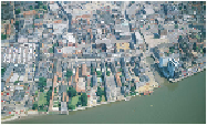
FIG
287.
Part of the King's Lynn waterfront (Fig. 275,
d1
). At the left-hand margin is the
large Tuesday market place, with numerous stalls. To the right of the obvious Purfleet
channel, near the right-hand margin, is the Saturday market place. (Copyright Norfolk
Museums and Archaeology Service & Derek A. Edwards)