Geoscience Reference
In-Depth Information
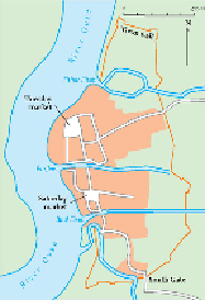
FIG
288.
Simple sketch map of medieval King's Lynn.
AREA 16: NORFOLK
Although Norfolk was famously described by Noel Coward in
Private Lives
as 'very
flat', it generally has a much more varied topography than, for example, the Fenland of
Area 15 to the west. It is true that the hills barely exceed 100 m in height, but there are
open valleys between the hills, and undulating plateaus are extensive.
The only part of Area 16 (Figs 289 and 290) that approaches the extensive flatness
of the Fens is the Broads area of east Norfolk, and both of these landscapes result dir-
ectly from the recent (Flandrian) rise of sea level that has followed the melting of ice
since the last (Devensian) cold episode of the Ice Age.
The most obviously recent landscape changes are those we can see taking place
in the coastal zone, arbitrarily defined here as ground less than 20 m above sea level.
These changes have been taking place over the last 6,000 years, since the rising
Flandrian sea reached approximately its present level. This general map of areas of
recent landscape change picks out the extent of the coastal zone, and also shows the
general pathways of the main present-day rivers, where the change of inland landscape
tends to be concentrated (Fig. 291).
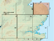
FIG
289.
Location map for Area 16.