Geoscience Reference
In-Depth Information
a)
e)
Surface
potential
Surface
potential
+
+
Current
electrode
X
X
X
X
0
0
Current electrode
Current
electrode
_
_
I
I
b)
f)
X
X
X
X
Current flow
line
Current flow
line
Cross-section
Cross-section
c)
g)
Equipotential
surface
Equipotential
surface
X
X
X
X
Map
Map
d)
h)
I
n
jection
well
Pumped
well
I
n
jection
well
+
+
Drawdown
Drawdown
0
0
_
_
Aquifer
Aquifer
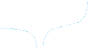
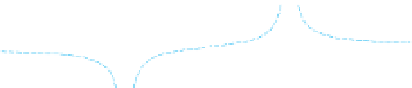
Figure 5.34
Electric
g) a dipole. The hydraulic
equivalents for both are shown in (d) and (h), respectively. Potential is measured with respect to zero potential, located at in
field in a half-space and the associated surface potential formed by: (a
-
c) an isolated pole and (e
-
nity.
5.6.2
Resistivity
Resistivity surveys map resistivity/conductivity in the
subsurface.
In
Section 5.2.1.2
we described how the resistivity (
In resistivity/IP surveying the electrical properties of the
subsurface are determined by measuring the current
passing through the ground via the current (transmitter)
electrodes, and measuring the resultant potential differ-
ence produced between the potential (receiver) electrodes.
The results depend on both the electrode configuration
and the actual subsurface distribution of the electrical
properties with respect
)of
a body could be determined by accounting for its geometry
also saw how measurements of the current (I)
ρ
flowing
through a resistor and the resultant potential difference
(
V) across it could be used to calculate its resistance (R)
using Ohm
Δ
to the
electrode
locations.
'
s Law (
Eq. (5.4)
).


Search WWH ::

Custom Search