Geoscience Reference
In-Depth Information
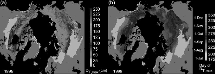
Figure 9.4.
Modeled maximum depth of active layer (a) and the date of maximum
thaw depth (b) for 1999 over the Arctic terrestrial drainage. Areas with no permafrost
in the drainage and the Greenland ice sheet are indicated by dark grey shading (from
Oelke et al.,
2003
, by permission of AGU). (See plate section for color version.)
streamflow via parameterizations of subgrid soil moisture variability, as well as spa-
tial variability in precipitation forcings and land cover. VIC is a research model and
has been applied to many watersheds across the globe. Originally developed in the
early 1990s (Liang et al.,
1994
), VIC is under constant development to respond to
new problems and applications. Considerable attention has been paid to improving
the representation of important high latitude processes such as sublimation, snow
redistribution, soil freezing, and the dynamics of lakes and wetlands.
NOAH:
The NOAH land surface model is a community effort led by NCEP and
involving collaboration between public and private institutions (Elk et al.,
2003
)
Originally developed in 1993, NOAH has been used operationally in NCEP NWP
models since 1996 and has undergone constant refinement. NOAH is an integral
part of the Weather Research and Forecasting (WRF) mesoscale numerical weather
prediction system designed for operational forecasting and atmospheric research.
CLM:
The Community Land Model (CLM) was developed for use within the
NCAR Community Climate System Model global climate model, which has subse-
quently evolved into the Community Earth System Model (CESM). CLM, a com-
munity effort, represents an evolution of land surface models beyond the treatment
of surface energy fluxes and applications to hydrometeorology to include biogeo-
chemical cycles (e.g., carbon and nitrogen cycles), land use, and vegetation dynam-
ics. It is built on the philosophy that terrestrial ecosystems are key determinants of
climate (Bonan,
2008
). CLM4, the latest version as of this writing, features revised
hydrology and snow parameterizations, organic soils, a 50 m deep ground column,
and updated distribution of plant functional types (Oleson et al.,
2010
).
CHASM:
CHASM (CHAmeleon Surface Model) was developed to explore the
complexity of the surface energy balance (Desborough,
1999
) and contains options
that allow it to utilize a range of hydrologic parameterizations and surface energy
balance configurations. In its simplest form it collapses to the simple “bucket”
model of S. Manabe (
1969
), whereas in its most complex mode it has a tiled mosaic
structure (e.g., Koster and Suarez,
1992
). A tile is a homogeneous land surface type