Geoscience Reference
In-Depth Information
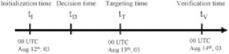
Fig. 16.5
Illustration of ensemble initialization time, decision time, targeting time and verification
time for adaptive sampling used in this study
daily time scale and faster time scale (on the order of every two hours) (
Leonard
and Robinson 2003
). With the ability to frequently update the glider plan, the time
for decision-making for optimal glider deployment can be shorter than other type
of platform deployment, such as aircraft equipped with GPS dropwindsondes for
upstream observation of significant weather event (
Majumdar et al. 2002
).
Key times involved in the decision-making process for the adaptive sampling
application of AOSN II glider observation are illustrated in Fig.
16.5
. The goal
of the adaptive sampling is to use an available ensemble forecast to identify the
future glider path that would maximally reduce the forecast error variance in the
verification region at the verification time. As an example, consider the ensemble
forecast initialized at the initialization time of 00 UTC Aug 12th. A new forecast will
be initialized at the targeting time of 00 UTC Aug 13th using targeted observations.
The decision time is the time when one must decide the location to which the glider
should be sent in order to minimize the error norm of the forecast to be initialized
on 00 UTC Aug. 13th. The verification time selected here is 00 UTC Aug 14th to
verify the forecast error reduction for the upwelled cold water transport across the
mouth of the Monterey Bay.
For a group of adaptive observations, the signal variance, which would be equal
to the reduction in forecast error variance in an optimal system, is used to identify
the best location for the deployment. The verification region is placed in a location
within which the ensemble variance is large at the verification time. This choice of
verification region increases the chances that the targeted observations will result in
a significant reduction in forecast error (
Bishop et al. 2006
). Figure
16.4
b illustrates
the fact that for a verification time 48 h from the ensemble initialized, at 00 UTC
Aug. 12th, there is a large ensemble spread across the mouth of the Monterey Bay
due to the uncertainty of the southward transportation of upwelled cold water from
Point Ano Nuevo. The verification region selected to enclose some of this high
spread region is shown by the ellipse on Fig.
16.4
b. The possible location for optimal
adaptive deployment can be tested in the two areas where the ensemble spread
is significant at the targeting time. As shown in Fig.
16.4
a, there are two possible
locations with one off the mouth of the Monterey Bay (location #1) and another one
in the south off Point Sur coast (location #2).
Nine adjacent “test” observations of surface temperature are placed for these
two locations centered at
122:1
ı
W, respectively and
used to calculate signal variance at the targeting and verification times (Fig.
16.6
).
There are high signal variances for both locations of the adaptive observation at
36:7
ı
N,
122:5
ı
Wand
36:2
ı
N,
Search WWH ::

Custom Search