Geoscience Reference
In-Depth Information
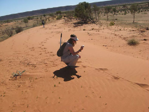
Fig. 11.12
A field photo of part of the dune system shown in Fig.
11.
13
. These dunes are still somewhat active (note the ripples) but are
partly vegetated. The large alternating footprints with a central groove,
indicating a large biped with a dragging tail, reveal the Australian
location—they are the tracks of a kangaroo. Jani Radebaugh for scale.
Photo R. Lorenz
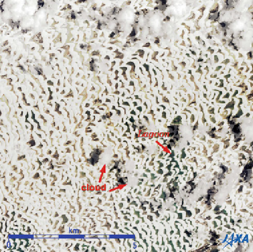
Fig. 11.10
Image of the Lençóis Maranhenses National Park, in
October 2007 from the Japanese Advanced Land Observation Satellite
(ALOS, aka Daichi). The white barchans and barchanoid ridges are
visible against the flat interdunes, but are very prominent against dark
lagoons. Earlier in the year, especially in rainy years, the entire area
can be flooded, yet evidently the region is dry enough for enough of
the time for sand to move and maintain the dune shapes. At these
equatorial latitudes, clouds are common. Image courtesy of JAXA
longest linear dunes found on Earth. Individual linear dunes
are in the Simpson range from 3 to 40 m in height (rather
small compared with the giants in the Namib and Arabian
desert) and are often partly vegetation-covered (Fig.
11.12
).
Nonetheless, some are traceable continuously for up to
200 km, and describe interesting patterns around topo-
graphic obstacles (Fig.
11.13
) that may be instructive in
interpreting Titan's linear dune morphology. Big Red
(Nappanerica) is one of the largest and most visited linear
dunes in the Simpson. Sand grains in the 'red center' are
heavily stained by iron oxide, forming some of the reddest
sands on the planet. Sand comprising the linear dunes
generally ranges from 0.05 to 1.2 mm in size, with 0.5 mm
as the average diameter on the dune crests and 0.3 mm as
the average on the lower flanks of the dunes (Twidale
1980).
Because the two authors reside in the United States, and
many of our readers may also, we offer some discussion of a
few more locations than their extent or dune size might by
itself demand. Twenty-two aeolian study sites throughout
the western United States are discussed in Zimbelman and
Williams (2007), along with their potential as analogs for
better understanding the sand dunes on Mars. The North
American deserts do not rival most of the world deserts
discussed above, but the semi-arid Mojave Desert in
southern California has been the site of aeolian studies for
many decades, and the Nebraska Sand Hills are an
impressive accumulation area for sand derived from the
recent glacial epochs. Below we highlight three of the more
distinctive dune locations within the western portion of the
continental U.S.
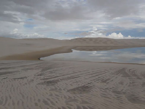
Fig. 11.11
A number of striking features can be seen in this field
photo at Lençóis Maranhenses. A cloudy sky is reflected in the placid
interdune lagoon. The dunes in the distance have wavy stripes,
corresponding to dry sand waves growing at the 'elemental' scale of a
few meters, as the sand dries and becomes mobile. Small bright
transverse ripples can be seen in the foreground, just a few cm apart
is collimated in straight lines,orcurved arcs at the right. This seems to
be where the moving bright sand has been trapped in the microto-
pography of bedding layers exposed in the damp dune surface. Photo
R. Lorenz

Search WWH ::

Custom Search