Geoscience Reference
In-Depth Information
Fig. 11.13
The shallow but extensive linear dunes of the Simpson
desert are seen here breaching through, and being diverted around,
a *100 m high ridge, southeast of Alice Springs. The fact that the
dune pattern appears to 'sense' the ridge more than 1 km away
indicates how topography can influence winds. Photo R. Lorenz from
an airliner
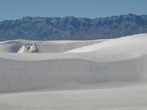
Fig. 11.14
Plant pedestal (left of center) preserved within the dunes
at White Sands National Monument, with ancient gypsum-bearing
sediment layers visible as white bands in the distant San Andres
Mountains (NPS photo)
sedimentary beds high in the San Andres Mountains
(Fig.
11.14
), which precipitates in playas on the basin floor,
and westerly winds transport sand-sized gypsum grains into
snow-white barchans and barchanoid ridges (Figs.
11.15
2007) cover 710 km
2
(275 mi
2
) of the basin floor. Evapo-
transporation is over 3 m annually, well in excess of the
annual rainfall, so the gypsum remains as individual sand
grains except where groundwater interacts with the base of
some dunes. The roots of some plants bind together enough
sand to produce pedestals within the active dune field (Fig.
11.14
). These gypsum dunes are important as potential
analogs to gypsum dunes identified in the north polar region
of Mars.
White Sands has been an important field study site;
bedding structures, exposed by brute force methods such as
on interdunes are shown in Fig.
5.23
.
The White Sands dune field has been nicely mapped by
considered in a model of boundary layer growth controlled
by the dune roughness (Jerolmack et al. 2012).
11.3.11 Great Sand Dunes
The highest dunes in North America are the Great Sand
2400 m (8000 ft) elevation above sea level, these dunes
have formed at an atmospheric pressure that is noticeably
less than that at sea level (something that becomes readily
apparent when a 'flat-lander' starts hiking up the dunes!).
The sand is derived from the San Juan Mountains, loca-
ted [100 km ([60 mi) to the west of the dunes, and they
have been concentrated by westerly winds against the base
of the Sangre de Cristo Mountains (see Fig.
8.1
). The
Sangre de Cristo Mountains are the source for granules and
pebbles carried by Medano Creek along the southern edge
of the dunes, where strong winds transport the granules onto
the lower portions of the dunes, creating wonderful gran-
ule-coated mega-ripples (Fig.
5.8
), features that are analogs
to similar mega-ripples on Mars (Zimbelman et al. 2009)
and whose movement has been documented (Lorenz and
Valdez 2011) with timelapse imaging (see Sect.
16.2.2
and
Fig.
9.9
). Niveo-aeolian activity on a parabolic dune near
11.3.13 Bruneau
11.3.12 White Sands
The tallest 'free-standing' (that is, not buttressed against
adjacent dunes or mountains) sand dunes in North America are
found near Bruneau, Idaho, located within an abandoned cut-
off meander of the nearby Snake River (Murphy 1973). Two
semi-parallel ridges of reversing sand dunes (Fig.
11.16
)
The world's largest gypsum dunefield is located in the
Tularosa Basin of southern New Mexico, between the San
Andres Mountains to the west and the Sacramento Moun-
tains to the east. Gypsum is leached from thick white


Search WWH ::

Custom Search