Geoscience Reference
In-Depth Information
(a)
(b)
(c)
High
High
Low
Low
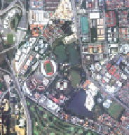
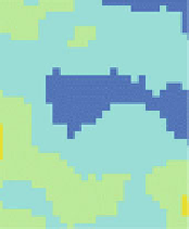
Fig. 6 a Orthophoto image, b NDVI map and c surface temperature map of the detailed study
area in Kelana Jaya
(a)
(b)
(c)
High
High
Low
Low
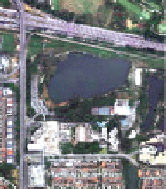
Fig. 7 a Orthophoto image, b NDVI maps and c surface temperature of the detailed study area in
Subang Jaya
(a)
(b)
(c)
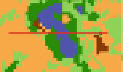
Fig. 8 Transection profile of surface temperature and NDVI for a Shah Alam Lake Garden
(Residential-urban park-water-commercial area) b Kelana Jaya Park (Built-up (Stadium Kelana
Jaya)-urban park (vegetation)-built-up (highway and industrial area)) and c Subang Ria Park in
2009 (Residential-vegetation (along road)-parking-water body-trees)