Geoscience Reference
In-Depth Information
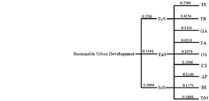
Fig. 3 Finalised AHP
decision model
considered not sustainable. Map 2 shows that only Daerah Sentral is considered
sustainable. Larkin and Permas Jaya are categorized as semi-sustainable. Overall,
the results show that the southern region of the study area is economically sus-
tainable (Fig.
4
).
4.2 Sustainability Based on Environmental Indicators
Figure
5
shows that all the planning blocks are sustainable. Map 3 shows that the
highest percentage of flood-prone area—Kangkar Tebrau—is only five percent,
followed by Teluk Danga (0.28 %) and Teluk Tebrau (0.07 %). Map 4 shows the
planning blocks that achieve sustainability on the public open space ratio, namely
Tebrau, Bandar Dato' Onn/Setia Tropika, Mount Austin/Taman Daya, Pandan/
Taman Molek, Tampoi and Tasek Utara/Teluk Danga. Each of them has more than
1.5 ha of public open space. Rinting, Pasir Pelangi, Permas Jaya and Kempas are
categorized as semi-sustainable planning blocks while the rest of the planning
blocks are not sustainable. Six areas are classified as environmentally sustainable
by achieving the highest score on both indicators. These are Bandar Dato' Onn/
Setia Tropika, Mount Austin/Taman Daya, Pandan/Taman Molek, Tampoi and
Tasek Utara/Teluk Danga.
4.3 Sustainability Based on Social Indicators
In Fig.
6
, Map 5 shows the population of JBCC with a total of 555,026 people.
The most populated area with a total of 70,141 people is Tebrau followed by
Bandar Dato' Onn and Setia Tropika with a total of 60,279 people. Pasir Pelangi is