Geoscience Reference
In-Depth Information
open framework acts as a buffer or valve, holding moisture
and protecting the easily eroded subsoil from direct rain
drop impact. The soil zone acts as an important reservoir
of water during dry periods since capillary uprise of water
through soil pores by the soil water's
osmotic potential
cre-
ates a flux that can take the place of water evaporated at or
near the surface. A
zero-flux
plane may be defined that
varies in depth seasonally according to land use and ther-
mal conduction; it separates upward-moving capillary soil
water from downward-moving recharge water. It usually
lies at a depth of a few decimeters to a meter or so. The soil
zone also allows a proportion of intercepted rain to natu-
rally
throughflow
at a rate that is directly dependant upon
the
infiltration capacity
of the soil in question. This is ini-
tially very high after a prolonged drought but measure-
ments suggest it eventually settles down to an equilibrium
value, the
saturated hydraulic conductivity
, controlled by
gravity. The rate of throughflow will thus depend upon
both the hydraulic gradient defined by the hillslope gradi-
ent and saturated hydraulic conductivity as expressed in a
form of Darcy's Law (Section 4.13) modified for flow
through partially saturated media. Areas of throughflow
convergence
, associated for example with slope concavities,
may cause significantly higher soil water saturation levels
and lead to
overland flow
. Such flows are extremely aggres-
sive since the tractive bed stresses imposed by turbulent
flow on steep hillside slopes, especially as the flow aggre-
gates into rivulets and minor channels, may cause extensive
erosion, rilling, and general environmental degradation.
However overland flow is usually only significant over
immature, severely desiccated, or disturbed soils, particu-
larly artificially indurated examples.
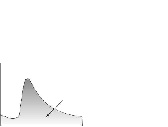
Concerning runoff becoming streamflow, the compo-
nents of the time-series of runoff are called a
hydrograph
(Fig. 6.58). We usually measure runoff in a channel as dis-
charge in cumecs (m
3
understand the sequence of events that starts with
background river discharge, involves a precipitation event
in the catchment, and ends with the passage of a flood
peak passing down the channel. We talk of
baseflow
to
describe the discharge that varies very slowly or not at all,
due mostly to near-constant supply from groundwater (see
the following sections).
Quickflow
is the contribution from
rainfall events. The shape of the flood hydrograph depends
on the many variables in a catchment that control the rate
of quickflow discharge, chiefly the infiltration capacity and
its controls like prior degree of soil saturation, desiccation,
occurrence of frozen ground, nature of natural vegetation
or land use, urbanization, and contribution of drains etc.
Human modifications are very significant in this respect,
for example, the USA has an area the size of the state of
Ohio under buildings or road surfaces. Hydrograph shape
also depends on the measurement site, for as the flood wave
passes downstream it may be heightened or diminished due
to tributary effects, floodplain storage, and so on.
Concerning
groundwater flow
, we have previously seen
how Darcy's Law (Sections 4.13) provides us with a sim-
ple but general approach via energy gradient to the flow of
fluid through porous media. Consider now the energetics
of slow and continuous groundwater flow through a
porous and permeable rock (defining an
aquifer
) in the
saturated zone beneath a water table (Fig. 6.59). At any
point along the aquifer the groundwater flow possesses
energy sufficient to keep up a certain height of water to a
measurable level in a manometer (piezometer) tube or well
drilled down to intersect the aquifer water table. Note first
of all that the water table is not a flat planar surface as its
name seems to imply. In fact it follows the general shape of
the topography, although in a “subdued” manner, rising
beneath hills and falling toward valley bottoms, intersect-
ing the surface at spring lines, lakes, or at river level. This
is because groundwater that flows away is usually being
replenished from above by infiltrating soil water. The rates
of the two fluxes determine the depth and slopes of the
water table. As shown in Fig. 6.59, groundwater flow is
along streamlines, always acting normal to and down
the maximum gradient of the equipotential surfaces
(Section 4.13). If there was no replenishment of ground-
water then the end result of potential flow would be a per-
fectly horizontal water table of minimum potential energy
where pore pressures beneath were all hydrostatic.
Catchment
hillslopes
are the feeder systems, not just for
water but for eroded soil, sediment, and rockfall to rivers,
lakes, and the ocean. Hillslope processes work mostly
under the influence of gravity. Thus sediment and soil par-
ticles are moved by combinations of kinetic energy transfer
during rain splash, by slow surface, and subsurface mass
s
1
). It is important to be able to
Basin lag is time between
onset rainfall and peak
Peak
Recession
limb
Base flow
separation
Storm
runoff
Rising
limb
Base flow
Time
Fig. 6.58
Hydrograph and terms used to describe it.


Search WWH ::

Custom Search