Geoscience Reference
In-Depth Information
flow termed
soil creep
, turbulent transport in overland
flow, by mass wasting from rockfall avalanches and, after
saprolite shear failure on steeper slopes, in slides, slumps,
and debris flows. Since these processes are all driven by
gravitational forces it is a truism to state that they are more
important in mountainous terrains. Large volume mass
failures are especially important in areas associated with
rapid active tectonic uplift of basically weak rock in oro-
genic belts. These are normally triggered by excess pore
pressures associated with either infiltration and through-
flow after abnormal rainfall events or by the effects of
seismic shock and fabric rearrangement associated with
major earthquakes.
when runoff or river flow is interrupted, usually because a
depression causes water build-up that cannot be neutral-
ized by seepage or evaporation. The commonest causes of
large lakes are tectonic subsidence and glacial erosion.
Lakes have great environmental and economic impor-
tance, for example their sink-like properties make them
highly important repositories of evidence for past climate
change, but, unfortunately, also for pollutants. Climate is
the chief modulator of physical lake dynamics; even the
world's largest lakes are too small to exhibit more than
minute tidal oscillations. Solar radiation provides energy
transfer through its control of surface water temperature
and hence density, giving rise to
thermal density stratifica-
tion
, the distinct layers differing not only in their density,
but also in chemical makeup. A temperate lake in summer-
time (Fig. 6.60) will show well-marked thermal stratification,
with an upper warm layer, the
epilimnion
, separated from
deeper, cold water that makes up the
hypolimnion
by
a layer of water exhibiting a changing temperature, the
metalimnion
. The
thermocline
6.7.2
Standing water: Lakes
Lakes are sinks for both water and sediment, cover about
2 percent of the Earth's surface and contain about 0.02
percent by volume of the biosphere's water. They form
defines a surface of
Stream
flow
Stream
flow
Streamlines
Equipotentials
Water table
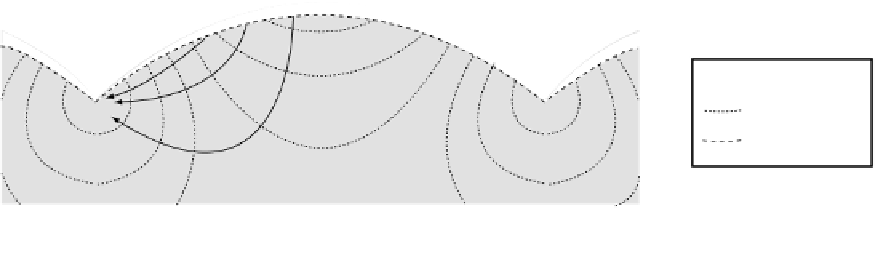
In 2D cross section the groundwater flow is always down the total energy gradient, d
f
/d
x
, determined by the slope of the line
joining the points of intersection of the water surface . This line is merely the intersection in 2D of a 3D potential surface that
maps out the elevation of the energy available to drive the groundwater flow. In fact, flow is always down the maximum
gradient in
f
. This is written as
f
for any surface. From Darcy´s Law the rate of flow is then
q
= -K
f
, where
K
is the hydraulic
conductivity. It can be seen that the expression for this groundwater potential flow is mathematically identical and physically
analogous to that for the flow of heat by molecular conduction and for the diffusion of ionic species along molecular
concentration gradients (Section 4.18). All the expressions relate to the mass movement of some quantity from higher to lower
potential surfaces. Since we are assuming that the conservation of mass applies then and (Cookie 2). The
latter expression is the celebrated Laplace´s equation which allows us to mathematically determine the variation of potential
flow fields in space.
.
q
= 0
f
= 0
Fig. 6.59
Computed groundwater flow net for symmetrical topography with an underlying mirror image subdued water table. Net comprises
equipotential lines and normal flow streamlines.
Wind shear
t
o
Wave setup
Buoyant plume
Drift current
Beachface
kinetic energy
transfers
Epilimnion
h
Thermocline
Gradient current
T
Hypolimnion
Autumn
convective overturn
plumes
Hyperconcentrated
und
e
rflow
Thermobaric density
Fig. 6.60
Generalised summary of physical processes affecting lakes.


Search WWH ::

Custom Search