Geoscience Reference
In-Depth Information
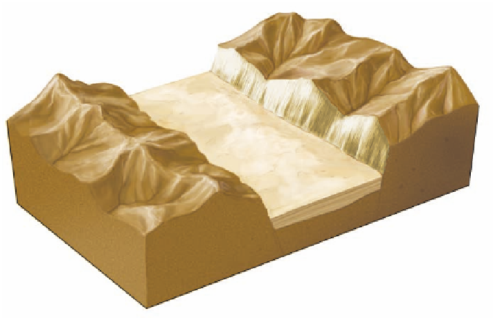
Figure 18.4 Formation of the Basin and
Range.
The Basin and Range Province
consists of a series of normal faults pro-
duced by stretching of the continental crust
over the past 20 million years. After uplift,
erosion attacks the mountain ranges (horsts).
The resulting sediments are then deposited
in the intervening basins (grabens), slowly
filling them with sediment.
Graben
(basin)
Horst
(upthrown block)
Fault planes
Horst
(upthrown block)
applied by an underlying magma plume. As a result of this
stretching, the crust thinned, cracked, and pulled apart, creat-
ing numerous normal faults that have planes inclined at about
a 60° angle (Figure 18.4). This faulting created the series of
alternating basins and ranges that characterize the area.
The importance of rock structure can also be seen where the
rocks are horizontal and have not been deformed (Figure 18.5).
In these areas, which are very common in the West, the rocks
usually consist of alternating layers of limestone, sandstone,
and shale that contribute to a distinctive pattern of differential
weathering. The limestones and sandstones are generally the
most resistant rocks to erosion, whereas the shales are rela-
tively soft and thus easily eroded. Where these patterns occur,
the hard rocks usually form a resistant caprock that protects
the underlying shale to some extent from erosion. Notice in
Figure 18.5 that shale tends to form shallow slopes, whereas
the more resistant rocks are associated with steep slopes. Shale
tends to erode backward gradually due to slope wash when it
does rain. This gradual slope retreat ultimately undermines the
caprock above and causes it to collapse due to rockfall, and the
cycle begins again.
The net effect of this kind of landscape evolution is
that large parts of the western United States are extensively
dissected (appear to be cut up), with upright landforms of
various sizes that rise above the surrounding lower ground.
To the novice these landforms seem to have some relation-
ship to one another, but it is difficult to imagine how they
could be related. Actually, this landscape represents a slow
progression of erosion over millions of years. Figure 18.5
illustrates the landforms associated with this progressive
evolution. It is interesting to notice how each of the rock
layers can be visually traced from one landform to another.
This linkage occurs because the rock was once a uniform
mass with broad regional extent. Through a combination of
stream erosion, differential weathering, and mass wasting
over millions of years, the landscape was slowly dissected,
leaving a succession of flat-topped remnants that tower
throughout the area.
Playa
Plain
Canyon
Mesa
Pediment
Mesa
Butte
Resistant cap rock
(limestone or sandstone)
Plateau
Pinnacle
Nonresistant rock
(shale)
Figure 18.5 Prominent desert landforms associated with horizontal rock structure.
Over time, a plateau
is dissected into progressively smaller landforms that give the region a distinctive appearance.