Geoscience Reference
In-Depth Information
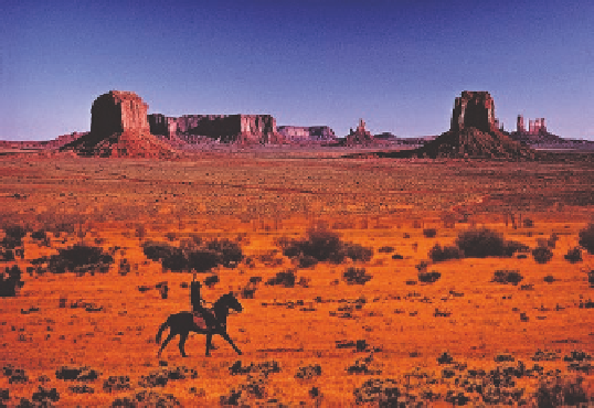
Figure 18.7 Landforms in Monument Valley, Utah.
This photo-
graph nicely illustrates the concept that the mesa, buttes, and pin-
nacles were once part of a uniform rock mass that was extensively
eroded over a long time.
of the dissected plateau. These combined processes gradu-
ally leave isolated remnants of the plateau standing alone in
progressively smaller and smaller landforms. You can easily
visualize this progression in Figure 18.5. The largest of these
plateau fragments is a
mesa
, which can be up to several kilo-
meters across. A somewhat smaller remnant is a
butte
, which
gradually wears down to form a tower-like landform called
a
pinnacle
. A great place to see these kinds of landforms in
close proximity to one another is Monument Valley in Utah
(Figure 18.7).
The net effect of the progressive dissection and shrink-
ing of plateaus, mesas, buttes, and pinnacles is that the land-
scape is gradually worn down into a series of rocky surfaces.
Where such a surface extends away from an escarpment of
the Basin and Range or cliff slope of a mesa or butte, it is
called a
pediment.
In other places, the intervening plains and
basins are covered with alluvium derived from long-term
erosion of hillslopes. A common feature in these areas is a
dried lake bed called a
playa
(Figures 18.5 and 18.8). Playas
are associated with closed topographic depressions that may
temporarily fill with water during wet periods. They sub-
sequently dry out during extended droughts, leaving salty
evaporites on the surface. These old lake beds often contain
a lengthy record of climate change and sedimentation in
the region.
Figure 18.6 A typical canyon in the western United States.
Canyons such as this one are very common in the region and
evolved as a result of vigorous stream incision. Exposed in the
canyon walls are layers of sedimentary rock.
The landforms produced by these long-term processes are
easy to see if you travel in the Southwest. A
plateau
is a broad
platform tens of kilometers across that is elevated up to perhaps
300 m (about 980 ft) above the surrounding terrain. Dissection
of a plateau occurs when a stream downcuts vigorously into the
underlying rock strata to form a
canyon
, which is a deep, nar-
row valley with very steep sides (Figure 18.6). The most spec-
tacular canyon, of course, is the Grand Canyon, but numerous
smaller canyons carve the landscape. As noted in Chapter 16,
this system of canyons is largely associated with the uplift of
the Colorado Plateau, which began about 30 million years ago.
This uplift increased the slope of streams dramatically, which,
in turn, prompted vigorous downcutting since that time (see
Figure 16.20a).
With the system of canyons in place, further stream ero-
sion and mass-wasting processes begin to attack the slopes
Plateau
A very broad, horizontal surface that is upheld by
resistant caprock.
Butte
A steep-sided hill or peak that is often a remnant of a
plateau or mesa.
A very steep-sided valley that is cut into bedrock.
Pinnacle
A steep-sided, narrow tower that is the final remnant
of a plateau, mesa, or butte.
Canyon
Mesa
A broad horizontal surface, smaller than a plateau, that
is upheld by resistant caprock.
Playa
A dried lake bed that forms when runoff collects in
closed topographic depressions in arid regions.