Geoscience Reference
In-Depth Information
in the formation of some drumlins by streamlining sediments
when periodic dramatic discharge bursts occur. Drumlins can
range in length from 100 m to 5000 m (300 ft to over 3 mi) and
can be as high as 200 m (650 ft). They often occur in “swarms”
and are particularly common in areas of Wisconsin, Michigan,
and New York where continental glaciation was particularly
intense during the most recent ice age.
Glacial Outwash
In contrast to glacial till, which is sedi-
ment that accumulates while in direct contact with an ice mass,
other sediments are carried and deposited by water that flows
out and underneath a glacier as it melts. This kind of sediment
is called
glacial outwash
and results from
glaciofluvial pro-
cesses
, which are the combined effects of glaciers and streams.
As a deposit, glacial outwash differs fundamentally from
glacial till in that it is well sorted, which means that most of the
sediments are roughly the same size, namely, sand and gravel.
This higher degree of sorting results from the fact that flowing
water naturally segregates sediments on the basis of their size
(see Chapter 16). For example, flooding stream systems deposit
sand near the channel (resulting in natural levees) and clays to-
ward the valley edge (forming wetlands and swamps). When
glaciers melt, they produce prodigious amounts of meltwater
that flows underneath and out in front of the ice. These flowing
bodies behave according to hydraulic principles and therefore
sort sediments in the same way as “normal” rivers do. These sed-
iments are also stratified, which means that distinctive layers of
sand, silt, or gravel can be traced horizontally for some distance.
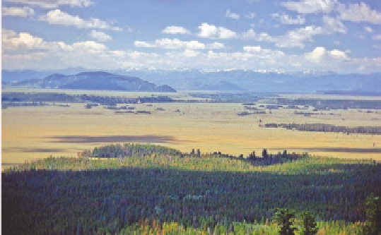
Deposition of glacial outwash creates some distinctive land-
forms. The most common and extensive glaciofluvial landform
is an outwash plain. As the name implies, an
outwash plain
is a
relatively flat landscape (Figure 17.25) that was created through
Figure 17.23 Ground moraine in the Blackfoot River valley
in Montana.
This rolling landscape was created because the
glacier was retreating slowly at the same time it was depositing
sediment in front and beneath it.
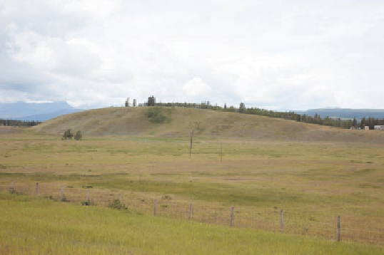
After till is deposited, it can be subsequently modified by
direct and indirect glacial processes, again leaving distinctive
landforms. One such landform is a
drumlin
, which is till or
other soft sediment that has been streamlined in the direction
of ice flow (Figure 17.24). A drumlin is somewhat similar to a
roche moutonnée, but, in this case, the blunt end faces the direc-
tion from which the ice advanced. The formation of drumlins is
not fully understood. Some may form because a glacier flows
over previously deposited till that has uneven resistance, per-
haps due to scattered boulder deposits or because some parts of
the till have a frozen core. As the glacier flows over the resistant
till, it may streamline less resistant sediment downstream of the
core. Also, meltwater at the base of the glacier may have a role
Figure 17.25 Outwash plain at Jackson Hole, Wyoming.
Note
the broad, horizontal surface that dominates the center of this im-
age. This landform evolved because meltwater streams deposited
the sediment in front of a valley glacier.
Figure 17.24 A drumlin in southern Alberta, Canada.
These
prominent hills were created by the streamlining effect of a glacier
on the sediment beneath it.
Drumlin
A streamlined landform created when a glacier
deforms previously deposited till.
Glacial outwash
Sediment deposited by meltwater streams
emanating from a glacier.
Outwash plain
A broad landscape of limited relief created by
the deposition of glacial outwash.