Geoscience Reference
In-Depth Information
the deposition of sediments carried by meltwater flowing out in
front of a glacier. The associated meltwater streams are usually
choked with coarse sediment and are therefore braided. Recall
that braided streams are associated with aggradation, which, in
the case of outwash plains, can result in very thick deposits of
water-laid sediment in front of the ice.
Another type of landform associated with glacial meltwater
is a
kame
, which is a large mound of sediment deposited by a
melting glacier (see Figure 17.20). The formation of a kame be-
gins when sediment accumulates in a depression on the surface
of a retreating glacier. The sediment is subsequently deposited
on the ground when the ice melts. A kame can form as an allu-
vial fan at the ice margin or as a deltaic deposit if the ice borders
a lake. Kames usually contain stratified deposits of sand and
gravel that progressively bury older deposits of a similar kind.
Kame landscapes typically consist of rolling and irregular hills
that are quite large, so large, in fact, that many ski resorts in the
upper Midwest are built on these landforms.
Yet another landform created by flowing water associ-
ated with a glacier is an
esker
, which is a winding ridge
(Figure 17.26) of coarse sediment deposited by a stream
flowing
under
the ice. In this instance, the cross section of a
subglacial stream channel is inverted with respect to a nor-
mal river channel; that is, the channel looks like an upside-
down U in cross section. The flowing water is confined by
the ice at the top and sides of the tunnel and by the ground
beneath it, and so is the deposition of sediment. When the
ice eventually melts, a meandering ridge of well-sorted and
stratified glacial sediment is left behind. Most eskers are
discontinuous because the conditions required for subgla-
cial fluvial deposition are difficult to maintain over long dis-
tances. Nevertheless, eskers can be over 30 m (100 ft) high
and tens of kilometers long.
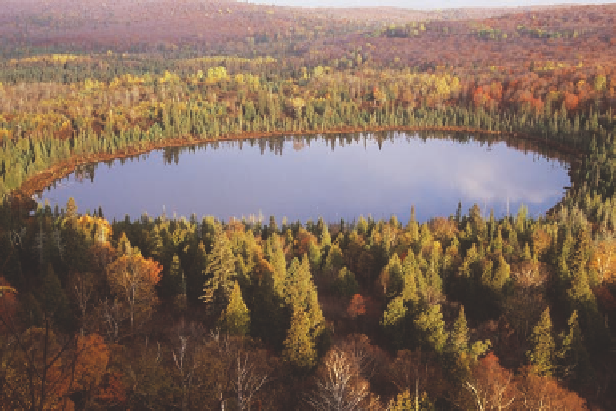
Still another kind of landform associated with glacial
outwash is called a
kettle lake
, which forms when a large
block of ice falls off the front of a glacier and is subse-
quently buried by glacial outwash as the ice retreats. At some
point, long after the glacier is gone, the buried block of ice
melts. In the process of melting, the block creates its own
lake, first by forming the depression that results from the
subsiding sediments, and second by providing the water to
fill the depression. This lake can subsequently be maintained
at its original size if the depression intersects the water table.
Kettle lakes are very common in heavily glaciated terrain
where they are scattered on the landscape (Figure 17.27). As
discussed in Chapter 15, the state of Minnesota is known as
the “Land of 10,000 Lakes” because it contains thousands of
kettle lakes that intersect the water table. The next time you
camp at a small lake in this area, or any similar place in the
northern tier of the United States, remember that the lake
probably evolved because an ancient ice block was buried
and then melted. Amazing.
Figure 17.26 An esker.
Eskers form when meltwater streams
flow in winding tunnels beneath a glacier, depositing sediment
that forms a ridge when the ice melts. This esker forms a promi-
nent ridge in Blue Lake, Minnesota.
Figure 17.27 Kettle lakes.
Kettle lakes form when ice blocks
break off the front of a glacier, are subsequently buried by glacial
sediment, and then melt, forming a depression and a lake if the
water table is high.
Kame
A large mound of sediment deposited along the front of
a slowly melting or stationary glacier.
Kettle lake
A lake that forms when a block of ice falls off the
glacial front, is buried by glacial drift, and then melts, forming
a depression that fills with water.
Esker
A winding ridge formed by a stream that flows beneath
a glacier.