Geoscience Reference
In-Depth Information
SD
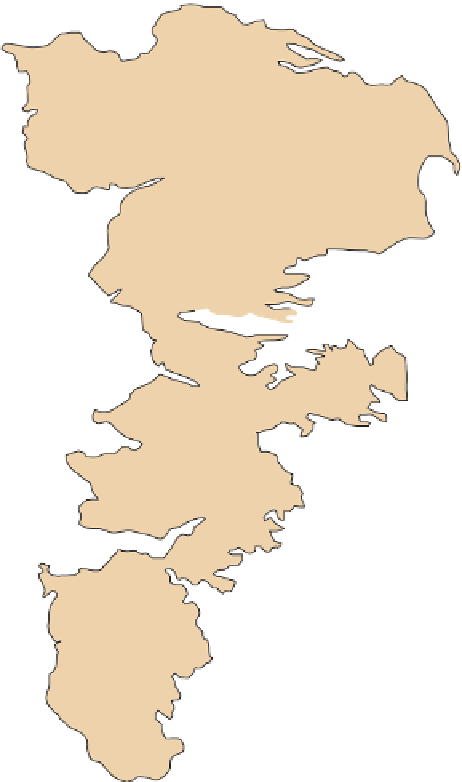
Figure 15.4 Geography of the
High Plains Aquifer.
This vast un-
derground reservoir of water under-
lies eight states in the central United
States.
NE
WY
IA
Omaha
at
e
CO
v
e
Denver
Colorado Springs
s
Ri
Kansas City
KS
Wichita
a
Albuquerque
Can
Oklahoma City
Amarillo
OK
Lubbock
NM
Dallas
Abilene
El Paso
TX
0
100
200 km
0
100
200 mi
As you can see in Figure 15.4 and Table 15.1, the High
Plains Aquifer is huge. It covers an area of about 280,000 km
2
(174,000 mi
2
) and contains 1,315,000 hectare feet (3,250,000
acre feet) of water. In other words, the aquifer contains the
amount of water required to cover over 1,000,000 hectares
(3,000,000 acres) to a depth of about 30 cm (12 in.). This vol-
ume is approximately equivalent to one of the larger Great
Lakes, such as Lake Huron. As you can see from Table 15.1,
the thickness of the saturated zone varies dramatically across
the region. In Nebraska, for example, the average saturated
thickness is currently 104 m (342 ft). In Colorado, on the other
hand, the average saturated thickness of the aquifer is only 24 m
(79 ft). This variation exists because the sediments are sandy all
the way to the surface in Nebraska, resulting in rapid infiltration
of water, whereas in Colorado they are covered in most places
by relatively impermeable deposits.
As discussed in Chapter 10, the Great Plains is one of the
most important agricultural regions on Earth, producing much
of the world's wheat, corn, and soybeans. One of the primary
reasons for this high productivity is that the soils are mostly Mol-
lisols, which, as we saw in Chapter 11, have thick, organic-rich
A horizons and B horizons laden with nutrients such as calcium
and magnesium. Despite the semi-arid environment, these fertile
soils attracted large numbers of farmers to the region in the late
1800s and early 1900s during the period of western settlement.
These farmers quickly learned, however, that the region could be
an unforgiving place for agriculture because precipitation could
be inconsistent and droughts often led to poor harvests.
The early settlers suspected that a large groundwater sup-
ply existed for a couple of reasons. First, they noticed that a
number of artesian wells were scattered throughout the region.
An
artesian well
occurs when the pressure applied by incom-
ing water elsewhere in the groundwater system causes water
to move up to the surface. This pressure can be enhanced by
a variety of factors, such as if a saturated zone is sandwiched
between two aquicludes, or because of faulting (Figure 15.5a).
Artesian well
A well in which water from a confined aquifer
rises to the surface through natural pressure.