Geoscience Reference
In-Depth Information
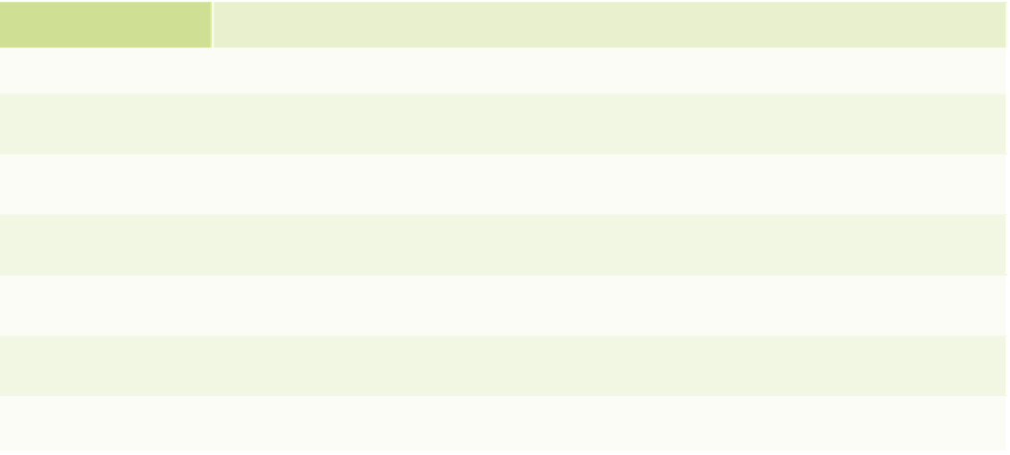
Characteristics of the High Plains Aquifer*T
T A B L E 1 5 . 1
Characteristic
Unit
Total
CO
KS
NE
NM
OK
SD
TX
WY
Area underlain by aquifer
mi
2
174,050
14,900
30,500
63,650
9,450
7,350
4,750
35,450
8,000
% of total aquifer area
%
100
8.6
17.5
36.6
5.4
4.2
2.7
20.4
4.6
% of each state underlain
by aquifer
%
14
38
83
8
11
7
13
8
—
Average area-weighted
saturated thickness in 1980
ft
190
79
101
342
51
130
207
110
182
Volume of drainable water in
storage in millions in 1980
acre-ft
3250
120
320
2130
50
110
60
390
70
*Modified from E. D. Gutentag et al., 1984,
Geohydrology of the High Plains Aquifer in Parts of Colorado, Kansas, Nebraska, New Mexico, Oklahoma, South Dakota,
Texas, and Wyoming
, U.S. Geological Survey Professional Paper 1400-B, p. 63.
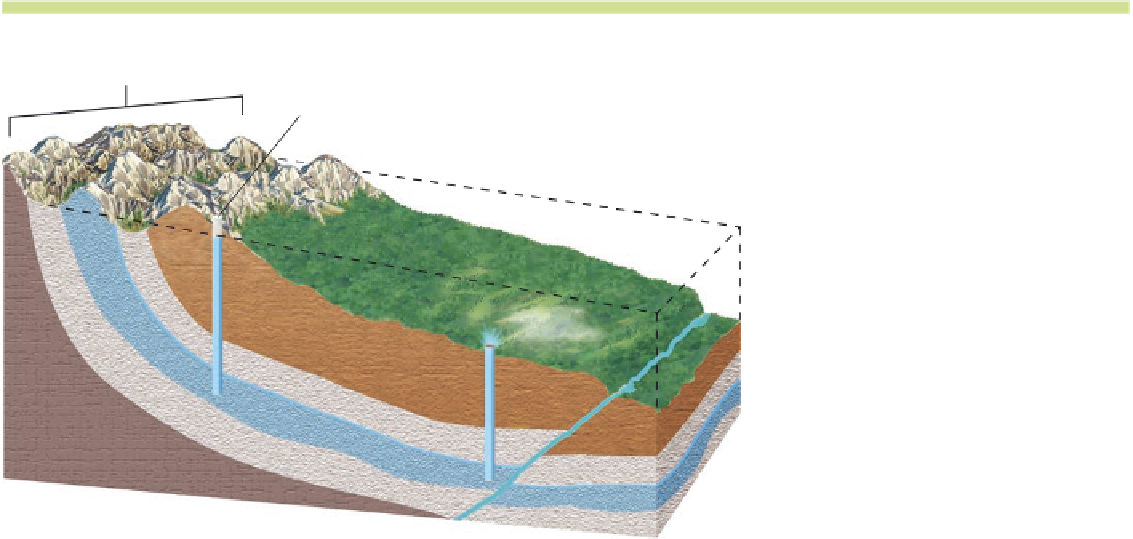
Figure 15.5 Artesian wells and
springs.
(a) When aquifers are
confined between aquicludes, wa-
ter may rise to the surface in an
artesian well due to pressure ap-
plied by incoming water elsewhere
in the aquifer. Where depressions
or channels intersect the water ta-
ble—for instance, at a fault—lakes
and streams develop. (b) A spring
is a place where water naturally
seeps out of the ground. This may
occur because the groundwater
lies between aquicludes, as in an
aquifer, or water may flow horizon-
tally along the contact between
overlying
Upland recharge area
Nonflowing artesian well:
top of well above upland water table
Water can rise to level of
upland water table
Artesian springs
Water table
Fault
coarse-textured
sedi-
ments and an aquiclude.
(a)
Flowing artesian well:
top of well below upland water table
Porous layer
(sand, limestone)
Sandstone
(porous)
Water
table
Water
table
Springs
Springs
Fault
Impermeable layer
(clay, shale)
Shale
(impermeable)
(b)