Geoscience Reference
In-Depth Information
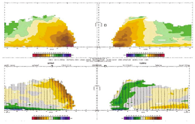
Fig. 8:
Airborne Doppler-analyzed vertical wind field across the centre of Hurricane
Katrina, 28 September 2005. Colour in the top panel denotes the tangential wind speed
(m s
-1
) and in the bottom panel the radial wind (m s
-1
). Arrows in the bottom panel
denotes the wind direction in the vertical plane.
Reasor et al. (2000) first documented TC mesoscale eyewall temporal
evolution with seven detailed true dual-Doppler analyses during a 3-h period,
focussing on the temporal evolution of asymmetries and the response of the
vortex to increasing vertical shear of the horizontal wind. They provided the
first evidence of vortex Rossby waves outside the eyewall, an important
confirmation of analytical and numerical studies of TC intensity change
(Montgomery and Kallenbach, 1997; Moller and Montgomery, 1999, 2000).
The next step is the assimilation of Doppler radar data into mesoscale
numerical models to improve our situation awareness and analysis. As model
resolution shrinks with advances in computing, the scale of information
necessary to initialize the model approaches that of a Doppler radar. Based on
the success in using the airborne Doppler radar to describe the axisymmetric
TC structure and major asymmetries it seems that the tropical cyclone problem
is the most tractable to attempt such an effort. In a TC, the dynamic constraints
are strongly controlled by the high vortex angular velocity. In a TC the time-
scale of the divergent component of the wind, which typically dominates the
variance in the Doppler winds, is one order of magnitude smaller than that of
the mean vortex. Data assimilation technique need to be designed that can take
advantage of this difference; one that limits the aliasing of convective motions
on the resultant initial condition. The problem seems tractable and should be a
high priority over the next 5-10 years.
Search WWH ::

Custom Search