Geoscience Reference
In-Depth Information
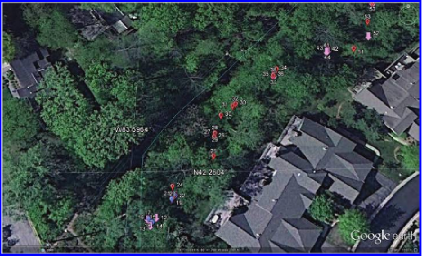
Figure 4.10 Pink arrows mark flags showing the County drain easements. Red bal-
loons mark trees within the easement to be saved. Blue balloons mark good trees
that will be cut. Source of base map and data: Google Earth mapping service ©
2012 Google and Image US Dept of State Geographer, © 2012 Google, Data SIO
NOAA US Navy NGA GEBCO, ©2012 MapLink/TeleAtlas.
from the camera images, as well as the images themselves, and make them cor-
respond to the underlying coordinate geometry in Google Earth. We made color
decisions to correspond with the actual colors of tags used on the vegetation.
Accuracy of the registration of photo and Google Earth coordinates, using
this sort of strategy, was guaranteed. Hand placement would not offer that
level of accuracy of registration. Overall, the results were sufficiently precise
(although not necessarily positionally accurate) to offer local residents a clear
picture of what was going to happen in their wooded areas. When the camera
GPS coordinates were obtained, a photo of the tagged item was also taken.
Figure 4.11
shows a photo displayed on the Google Earth surface pointing
to the identified tree.
Figure 4.12
shows a similar configuration of a photo in relation to the Google
Earth base. This time, the photo shows a tree with a blue tag. Note that there
is a pointer on the margin of the photo that points to a blue balloon.
The neighborhood association established a tree monitoring committee. The
committee was armed with a Google Earth file showing tree locations and
associated tag colors. The easement was also geocoded. Prior to using the file,
the neighborhood association president and the creator of the Google Earth
display met with the lead County official on the project and the lead engineer
Search WWH ::

Custom Search