Geoscience Reference
In-Depth Information
We next visited the wharf area immediately adjacent to the fishing port to view the
new 40 to 50-ton tetrapods being used in the construction of the offshore breakwaters.
This new offshore breakwater system started a couple of years ago with two small
sections totaling about 200 meters completed to date. Another 10 or more years will
be required to complete a total of about 2 kilometers of offshore protection. The
design wave height for this project is approximately 8 meters with the breakwater
height about 0.6 times this wave height above the mean high water level.
One of Japan's strategic below ground oil reserve storage areas is located at the north
end of Kuji Port, however we were not allowed to enter this facility. At this point we
returned to the town of Kuji reaching our hotel at about 5:30 pm. Prior to going out
for dinner our entire team met at the hotel to discuss our upcoming plans. To help us
keep track of the coastal sites and plan the remainder of our trip, PARI supplied each
of us with a notebook of reports, photos and inundation maps. This first day was a
long and busy day with even busier and longer days ahead as we travel through the
areas most heavily damaged by the tsunami.
Day3—Friday,May13
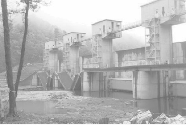
Figure A.3 Fudai River Gate, collapsed roadway on inland side of flood gates.
(Source: Catherine Petroff)
Our team left Kuji in the morning under a misty rain. As we drove again past Noda,
fog obscured the devastation we had surveyed the previous day. Our first stop was at
the four tsunami gates at the mouth of the Fudai River, seen above.
These gates are 20 meters long and four meters high, and were completed in 1984. In
this location, the tsunami height was generally around 20 meters above sea level,
Search WWH ::

Custom Search